-
 Duration
14 Days
Duration
14 Days
-
 Difficulty
Slightly-hard
Difficulty
Slightly-hard
-
 Max Elevation
5,357 m
Max Elevation
5,357 m
-
 Group Size
1 to 10 Person Person
Group Size
1 to 10 Person Person
-
 Accommodation
Tea House/Lodge
Accommodation
Tea House/Lodge
-
 Start/End
Kathmandu Airport/ Kathmandu
Start/End
Kathmandu Airport/ Kathmandu
-
 Destination
Everest Region
Destination
Everest Region
-
 Best Season
Mar - May and Sep - Nov
Best Season
Mar - May and Sep - Nov
Gokyo Lakes Trek is one of the most beautiful trekking trails in the Everest region that follows the Dudh Koshi valley and then runs into the serene.
Gokyo valley where a chain of glacial lakes lies in the presence of enormous Himalayan peaks.
Compared to the regular Everest Base Camp trail, the trail traverses smaller Sherpa villages, alpine grazing fields, and glacier scenery, and finally arrives at the blue lakes of Gokyo and the summit viewpoint of Gokyo Ri.
The expedition usually starts with the flight from Kathmandu to Tenzing-Hillary Airport, the entrance to the Khumbu. The path descending out of Lukla to the Dudh Koshi river goes through hamlets such as Cheplung and Ghat, and finally to the small hamlet of Phakding.
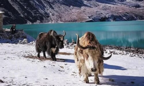
This initial portion of the hike is along forested river valleys densely laden with pine, rhododendron, and magnolia. Suspension bridges span the river, and villagers at the upper part of the valley have their supplies being transported up and down the trail by yak caravans.
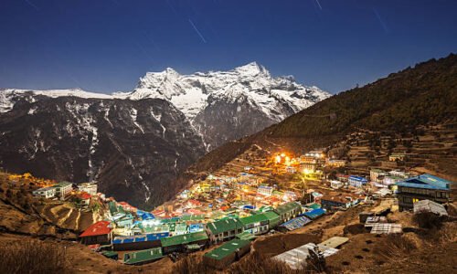
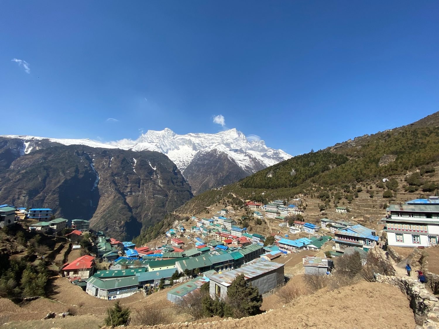
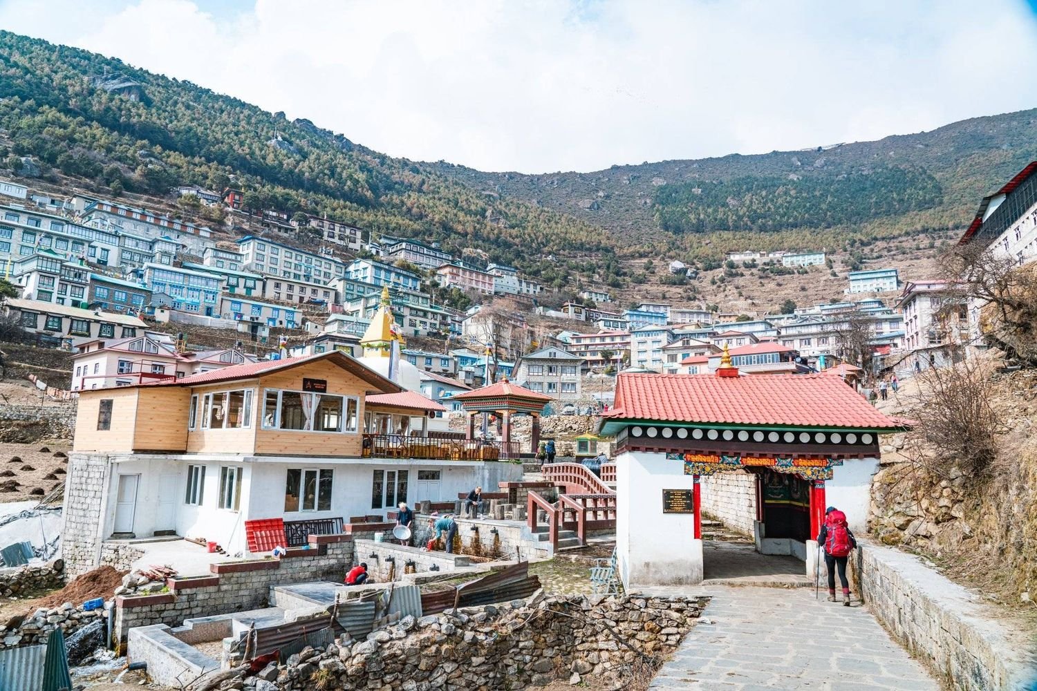
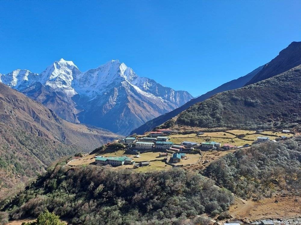
Days that follow are further within the Sagarmatha National Park, a reserved Himalayan terrain that is reputed with forests, wildlife, and extreme mountainous terrain. The trail ascends slowly up to the Sherpa trade center of Namche Bazaar, which is the biggest town in the area.
Namche is located in a natural amphitheatre at an altitude of approximately 3,440 meters and acts as the business and cultural centre of the Everest region. Trekking equipment and food stores, bakery, and even local markets are still active centers of trading between people who come both to Tibet and the neighboring valleys.
One day of acclimatisation is usually allowed to the trekkers, who then proceed further up the mountains.
Out of Namche the path goes off the usual route north-west to Gokyo valley, the rest of the Everest Base Camp. The trail ascends to tiny Sherpa towns, including Mong and Phortse Thenga.
It cuts through rhododendron bushes and open valleys, providing spectacular Bigger Snowy Mountain views of Himalayan peaks like Ama Dablam, Kangtega, and Thamserku.
Days spent walking at this level take the usual norm of five to seven hours and the altitude increase is rather slow, giving the trekkers time to acclimatize to the thin air.
On the other side of the valley is the little village of Dole. Dole is basically a group of mountain lodges and yak grazing lands where animals are taken by herders during the summer seasons.
The change of landscape starts here. The trees become extinct, and the land turns alpine and rocky.
The atmosphere is colder, and the landscapes are open to high mountains and glacial valleys. This village is the point of entry of the forest mid-hills into the high Himalayan setup.
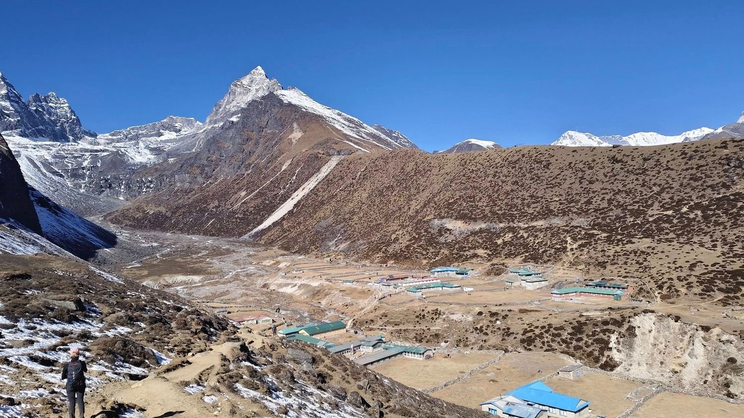
The second significant point of interest is Machhermo, which is situated at an altitude of approximately 4,470 meters along the Dudh Koshi river valley.
The final permanent place before the Gokyo lakes is Machhermo, which is characterized by small lodges that accommodate trekking crews.
It is common with many trekkers since people can get acclimatised at the altitudes that are above four thousand meters. Medical posts are present here as part of the Himalayan Rescue Association, and they give information about high altitude sickness and the safety of trekkers.
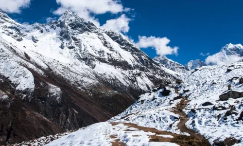
Machhermo turns the landscape drama and a glacial. The path then steadily ascends over small seasonal villages like Pangka and Thanak.
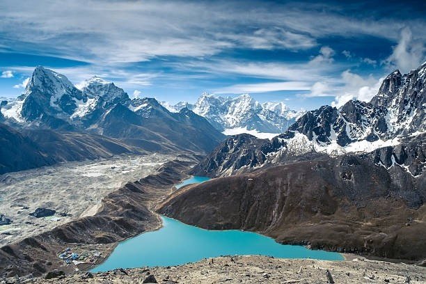
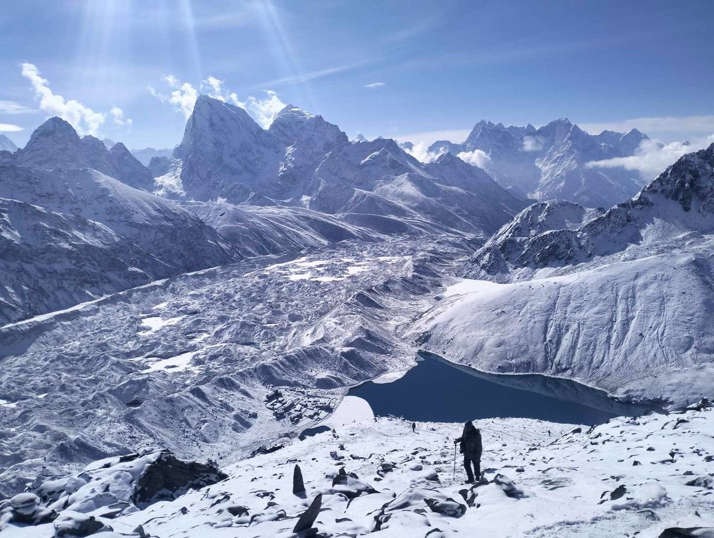
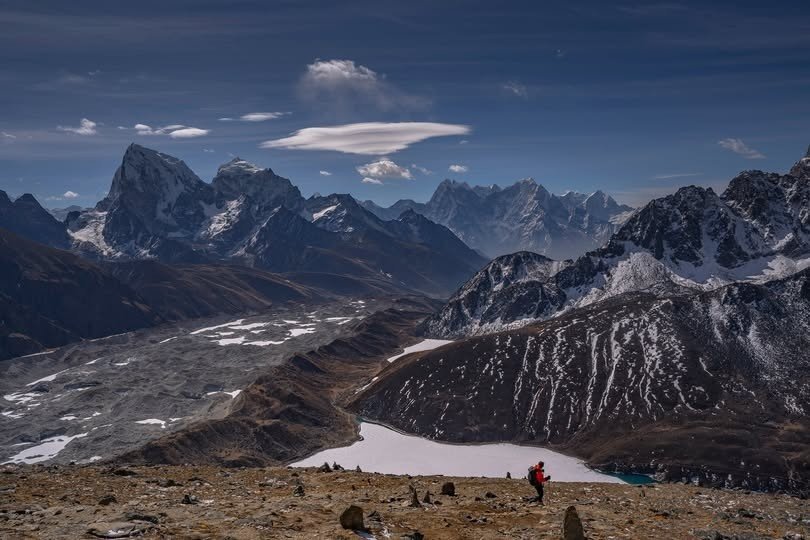
It reaches up to the fringes of the very lengthy Ngozumpa Glacier, the longest glacier in the Himalayas. The terrain is dominated by moraine ridges and rocky paths.
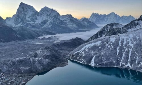
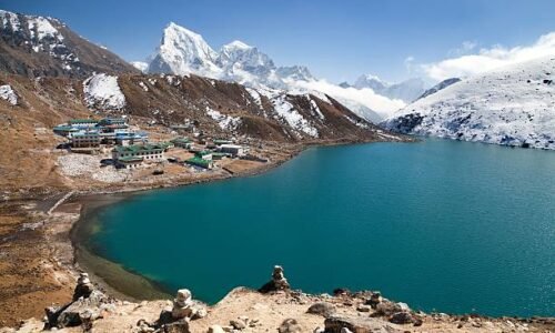
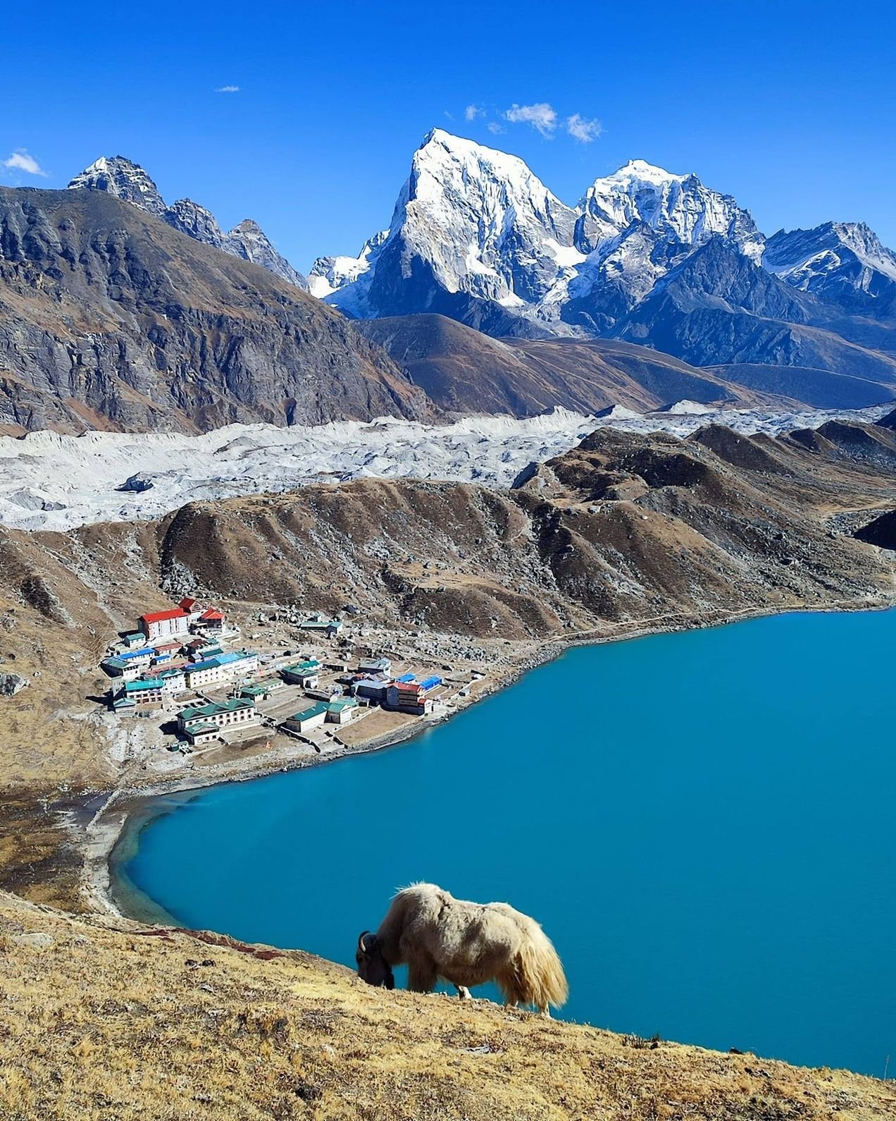
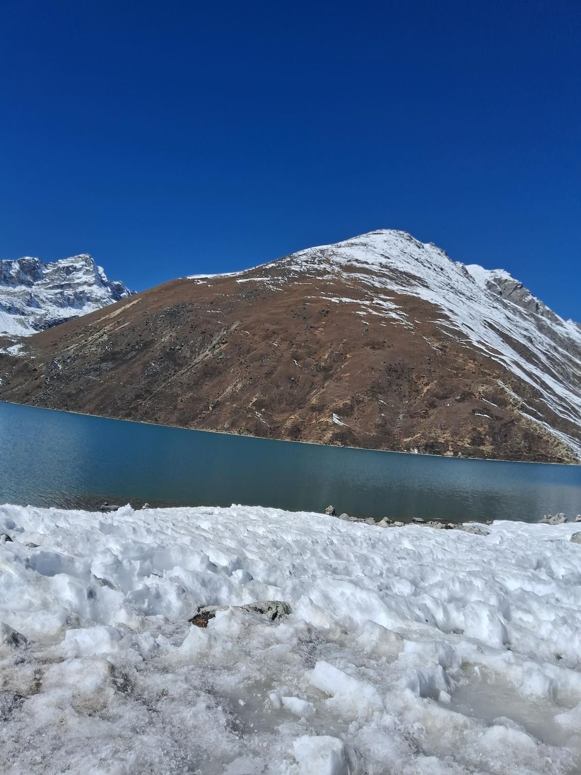
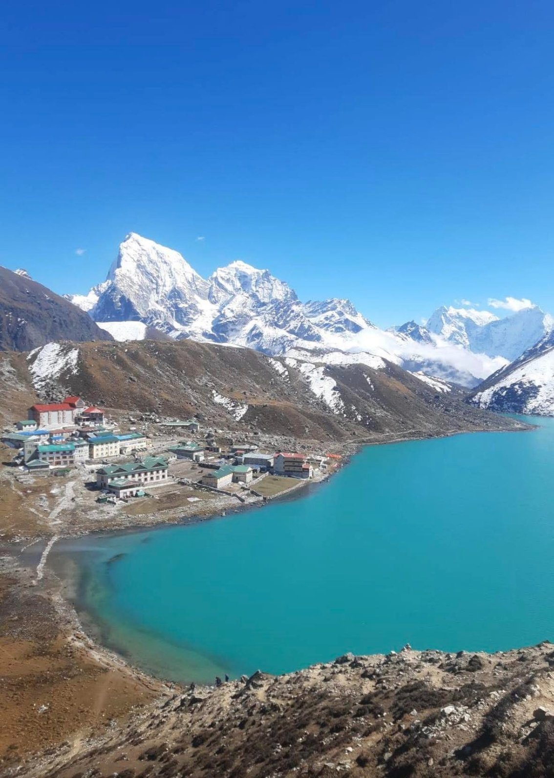
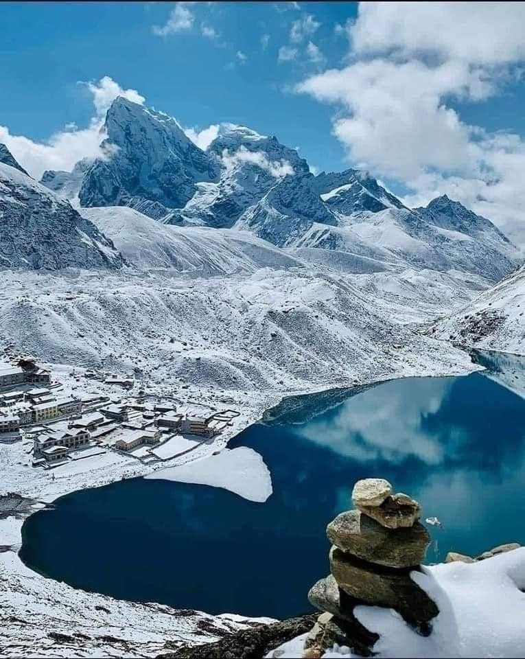
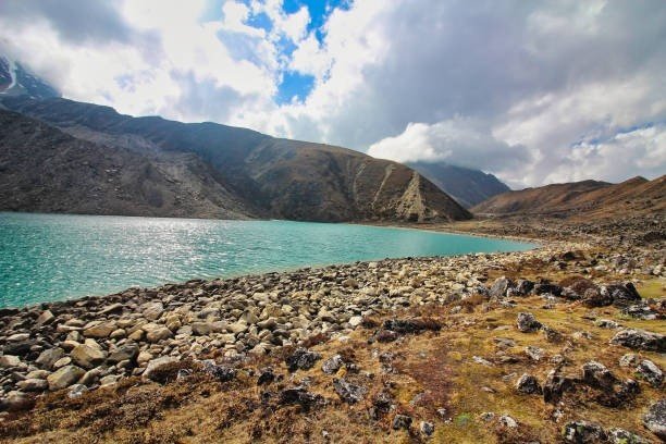
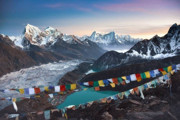
The first of the well-known lakes in Gokyo is seen on the way. These glacial waters create an unbroken chain of six turquoise lakes fed with ice and snow melting in the neighboring panorama.
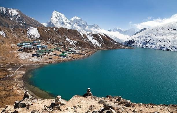
Gokyo has its main settlement next to the third lake, Dudh Pokhari, which is approximately 4,800 meters. There are works of small stone lodges along the lakeside and prayer flags cross the valleys above the water.
Gokyo is a simple and pleasant accommodation. The majority of lodges have twin rooms, common eating areas that have fire stoves made of wood or yak dung.
Basic foods include dal bhat and soups, noodles, potatoes, and tea. Nights at this altitude are chilly and silent, and the glacier and mountains that surround it establish a theatrical backdrop of the Alps.
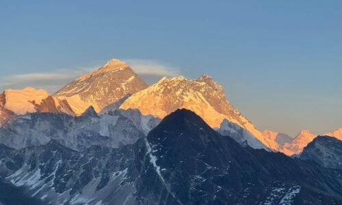
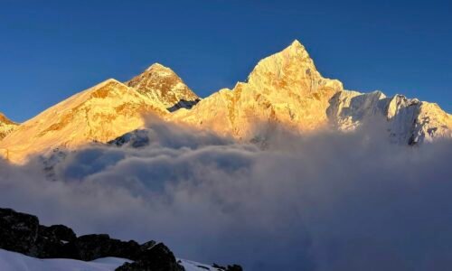
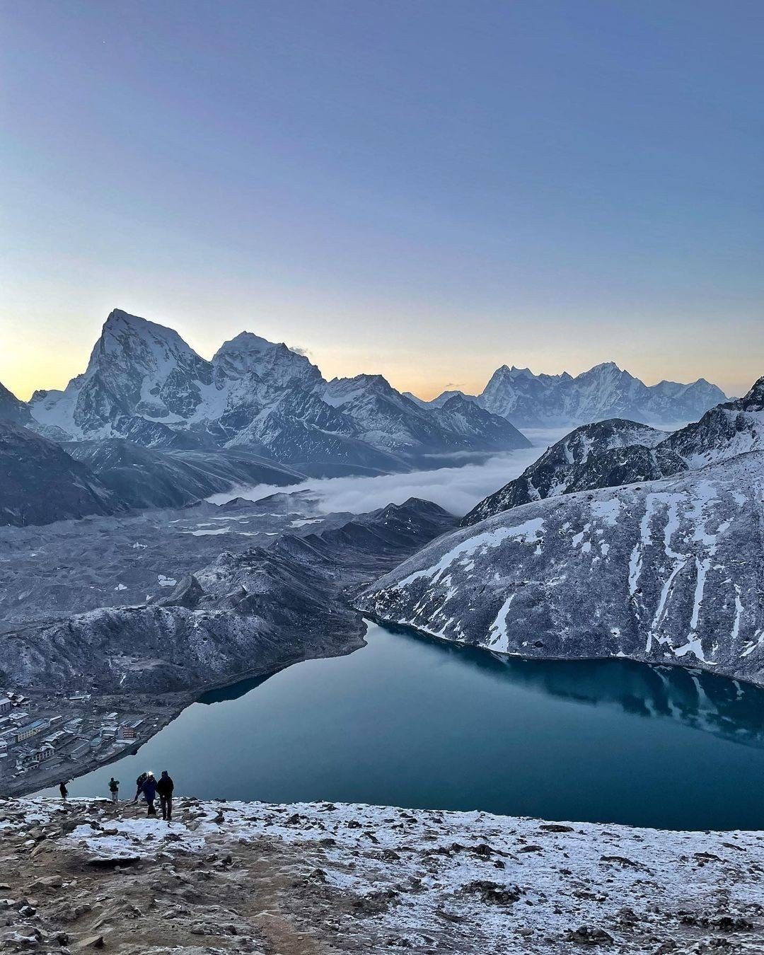
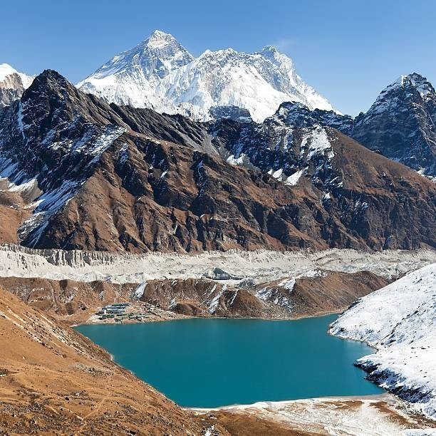
The early morning summit to Gokyo Ri, a rocky mountain that extends above the village to an approximate height of 5,357 meters, is among the highlights of the trek. The ascending period of the mountain is often pre-sunrise and two-three hours long.
The best panorama in the Himalayas is seen there when one is on top of it. We can see the four highest mountains of the world such as Mount Everest, Lhotse, Makalu, and Cho Oyu.
Below the entire series of Gokyo lakes can be seen. Across the valley floor runs the gigantic stream of the Ngozumpa Glacier.
Wild animals are sometimes seen on the road, particularly in the lower woods and the alpine plateaus. On rocky areas, Himalayan thar, musk deer, and ghoral are occasionally found.
Birds like the Himalayan monal pheasants are found in the forest areas. The trek is dominated by yak caravans, which is a common aspect of everyday living in the high valleys.
The usual trekking days in the path are five to seven hours of walking in relation to the altitude and the terrain. The walk quite often includes about eighty to ninety kilometres over approximately ten walking days.
The rest days are usually planned in Namche Bazaar. Occasionally, rest days are also spent near Machhermo or Gokyo in order to adjust the trekkers to the altitude.
Even though the Gokyo Lakes Trek takes an average of thirteen days, most trekkers opt to spend more time on the trek. Crossing a high mountain pass, Cho La Pass is one of the most favorite extensions.
The trail then leads to the Everest Base Camp and Kala Patthar. This extra 2 to 3 days circuit typically transforms a trip into a bigger journey of the Everest region, comprising glaciers, high passes, and base camp vistas. If you want to extend your stay, we, at Nepal Royal Treks will guide you accordingly.
The trip back from Gokyo is usually the same direction through Machhermo, Dole, and Namche. The trail then descends down the Dudh Koshi valley to Lukla. The last day is also capped with a mountain flight back to Kathmandu.
The Gokyo route is unique because there is a combination of scenes and serenity. The valley of Gokyo is less crowded and less bustling compared to the crowded trail of the Everest Base Camp.
The way is a combination of Sherpa culture, alpine lakes, glacier scenery as well as the finest mountain scenery in the Himalayas. It is one of the most fulfilling treks in Nepal.
This is one of the reasons why trekkers who seek a scenic Everest region will go there. The trek also provides some flexibility to the traveller who wishes to have a longer journey to the Himalayas.
There is the option to cross on the high pass onwards to Everest Base Camp or enjoy other high passes organized by the local company like Nepal Royal Treks.
Trip Highlights
- Hike the line of sacred mountain lakes, with their clean blue water and decoration of prayer-flags. Pilgrims and travellers are lingering about, in a peaceful highland oasis in the middle of the Himalayas.
- Wake up early and go up Gokyo Ri (5,357 m) to have a panoramic sunrise view. The 360 Degree perspective covers Everest, Lhotse, Makalu and Cho Oyu, which are above Ngozumpa Glacier. To a great number, this perspective is even more spectacular than the traditional Everest Base Camp perspective.
- Cross the lateral moraine of the longest glacier in Nepal, Ngozumpa Glacier. It is a very distinct glacial landscape in the Everest region looking down upon the river of ice rushing slowly down to lower valleys.
- Remain in old Sherpa settlements such as Namche Bazaar and Khumjung. The carved mani stones, colorful chortens and the hospitality of teahouse lodges are worth admiring. Monasteries and festivals here celebrate a mixture of the Tibetan Buddhism and mountain culture.
- There will be dozens of Himalayan giants on the clear days. Besides Everest (8,849 m) and the pyramid of the Mt. Ama Dablam, the wide bulk of Makalu and Cho Oyu stand out in the skyline.
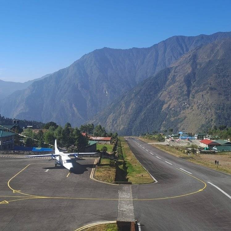
- Start and finish your adventure with one of the most dramatic flights ever in the world. Lukla airport (2,840 m) is tiny, and in a location that is precariously placed on the ridge of a mountain which creates extreme views of the Khumbu peaks and valleys when landing and taking off.
- The path on the bottom leads through rhododendron and pine forests. Hiking in the spring entails the season of flowers. There is a possibility of seeing timid animals like musk deer, Himalayan tahr and birds like the pheasant and monal; the ecosystem is conserved by Sagarmatha National Park.
- The Gokyo trail is an extremely untravelled route compared to the traditional Everest Base Camp trail. This is more freedom, fewer teahouses and a sense of actual wildness.
- Other than the Gokyo Ri there are shorter high view points such as the Bangla near Namche or minor passes above Dole that offer new views of Everest and the nearby mountains.
- The increasingly rising camps make you feel as though you have made some progress every days you ascend higher and the air becomes more thin, with its ultimate concluding in the peaceful lake camp at Gokyo. Dal Bhat and Noodle Soups will keep you warm even at 4,700m.
Gokyo Lakes Trek — 14 Days ~ Itinerary
Day 1
Arrival at Kathmandu Airport - Welcome to Nepal
- Altitude: 1,350 m
- Accommodation: Standard Three Star Hotel
- Meal: Provided for rest of the day depending upon your flight
Welcome to Nepal! Upon arrival in Tribhuvan International Airport, our team will take you to Kathmandu hotel. You can spend the day in leisure, tour the bright streets of the Thamel and come to a trekking orientation session in the evening including gearing check and permits briefing
Day 2
Fly Kathmandu to Lukla and Trek to Phakding
- Max altitude: 2840 m
- Flight Duration: 30-35 minutes
- Trek Duration: 3-4 hours
- Trek Distance: 8 km
- Meal: Breakfast, Lunch and Dinner
- Accommodation: Teahouse in Phakding
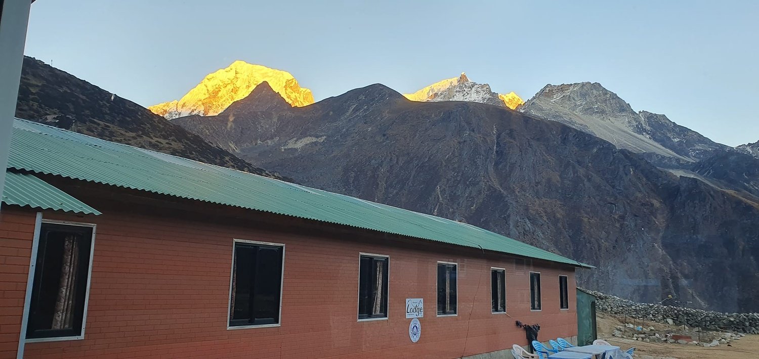
Head to Tribhuvan Int’l Airport for the Mountain Flight to Lukla. While approaching the airport, which is on a steep hill, enjoy the view of Everest range. From Lukla we immediately begin trekking down-valley along the Dudh Koshi River. The trail passed through pine and rhododendron woods, passing small villages like Chaurikharka. After several suspension bridge crossings and couple of hours walking, we reach Phakding (2,610 m). This quiet village has stone guesthouses and stunning views of nearby peaks such as Thamserku, Kusum Kangaru, Kongde Ri, and Nupla.
Day 3
Phakding to Namche Bazzar
- Max altitude: 3440 m
- Trek Duration: 5-6 hours
- Trek Distance: 10-12 km
- Meal: Breakfast, Lunch and Dinner
- Accommodation: Teahouse in Namche
The trail that we have today slowly winds out of the valley of the Dudh Koski. There are numerous suspension bridges and one of the most well known ones is the Hillary Suspension Bridge (1,850 m) where Everest can be seen. It then climbs up to a rhododendron forest, getting steeper in the village of Monjo (entrance to Sagarmatha NP). Once you go through the Sagarmatha park gate and additional woods, you take on a final climbing above the tree line. Namche Bazaar, which can be found on a hillside, is a busy Sherpa village with teahouses and shops. Namche is a large-scale view of Ama Dablam and the south face of Everest. Take up in your Teahouse/lodge, and watch the alpine sunset.
Day 4
Acclimization in Namche Bazaar
- Max altitude: 3880m
- Trek Duration: 4-5 hours
- Trek Distance: 5-6 km
- Meal: Breakfast, Lunch and Dinner
- Accommodation: Teahouse in Namche
This is a rest day so that your body can slowly adjust to the altitude. In the morning, you can take a stroll to around the Hotels, which is at 3,880m or visit the observation points that are nearby to capture mornings of Mt. Everest, Lhotse and Ama Dablam. At your convenience, you can go to the Sherpa village of Khumjung (3,790 m) and the monastery of the village. Then go back to Namche and have lunch. Go to the market and in the museum in the afternoon. The high altitude area of Namche and the perspectives provide you with even more beautiful scenery making it one of the best high towns in Nepal.
Day 5
Namche Bazaar to Dole
- Max altitude: 4038 m
- Trek Duration: 5-6 hours
- Trek Distance: 10 km
- Meal: Breakfast, Lunch and Dinner
- Accommodation: Teahouse in Dole
Day 6
Dole to Machhermo
- Max altitude: 4470 m
- Trek Duration: 4-5 hours
- Trek Distance: 8 km
- Meal: Breakfast, Lunch and Dinner
- Accommodation: Teahouse in Machhermo
This is a shorter day with some stiff climbing. From Dole the trail heads northeast, slowly toward Machhermo Pass . The landscape opens up to high alpine meadows and summer open lands with yak herds. On a clear morning you may see the Nirekha (7,000m) peaks facing the Ngozumpa Glacier. We then descend a bit into Machhermo village, located on the valley floor with a panorama of steep ridges all around. Machhermo has a few basic lodges, make sure to enjoy the mountain views as you settle in.
Day 7
Machhermo to Gokyo
- Max altitude : 4800 m
- Trek Duration: 3-4 hours
- Trek Distance: 5-6 km
- Meal: Breakfast, Lunch and Dinner
- Accommodation: Teahouse in Gokyo
We arrive at the Gokyo Lakes on the seventh day of our trek. The path leaves Machhermo, and ascends smooth above the valley, making a slight turn of the lateral moraine of the Ngozumpa Glacier. You walk past piles of old driftwood and big rocks left behind long ago when glaciers moved through this valley. The first of the Gokyo Lakes is seen after a last short steep walk. Gokyo village (4,750 m) is located on the shore of the third lake and is surrounded by stone lodges and prayer flags. Spend the afternoon exploring the first, second and third lakes; look for reflections of Mt. Cho Oyu in the water.
Day 8
Gokyo to Gokyo Ri
- Max altitude : 5357 m
- Trek Duration: 4-5 hours
- Trek Distance: 6-8 km
- Meal: Breakfast, Lunch and Dinner
- Accommodation: Teahouse in Gokyo
A big day of our trek. A moment we have waited for over seven days. On this day, we wake very early (before dawn) to climb Gokyo Ri, a steep summit, located directly above the village. The final scramble to the top takes 2–3 hours, but the sunrise view is unforgettable. From the summit you see nearly half of the world’s 8,000m peaks: Everest, Lhotse, Cho Oyu, Makalu and more filling the horizon. After soaking in the panorama, descend back to Gokyo village for lunch. In the afternoon you can optionally walk to the fourth lake (about 2 km west), though the main attraction is already behind you. This evening relax after the trek’s highest climb and look back at the memories and pictures along with your travel companion.
Day 9
Rest in Gokyo
- Max altitude : 4000 m
- Trek Duration: 2-4 hours
- Trek Distance: Depends on Hike
- Meal: Breakfast, Lunch and Dinner
- Accommodation: Teahouse
Take a leisurely day in the Gokyo Valley. You can rest at the village, or do a small hike to nearby high points. Many trekkers walk up to the 4th lake (Thonak Chö) for a close look, or hike to Renjo La ridge. This day helps recover from yesterday’s climb. You could also get a chance to see Wildlife like mountain goats or pheasants. Otherwise, enjoy views of Cho Oyu and the glacier from Gokyo village itself.
Day 10
Gokyo to Machhermo
- Max altitude : 4800 m
- Trek Duration: 10 km
- Trek Distance: 5 hours
- Meal: Breakfast, Lunch and Dinner
- Accommodation: Teahouse in Machhermo
We begin the trek back out of Gokyo towards Macchermo. The walk is unsurprisingly easier, but still longer. Take breaks to admire the lakes one last time. Crossing the moraine, the wide views of snowy peaks gradually give way to more vegetation. You arrive in Machhermo by late afternoon. Enjoy the quieter trail on the return and compare how different the glacier looks from the other side.
Day 11
Machhermo to Namche Bazaar
- Max altitude : 3440 m
- Trek Duration: 6-7 hours
- Trek Distance: 12 km
- Meal: Breakfast, Lunch and Dinner
- Accommodation: Teahouse in Namche
A long day descending back to the tree line. The trail drops steadily from Machhermo past Dole and on to Namche. In the upper valley you walk through moraine and sparse alpine juniper. As altitude lowers, rhododendron forests reappear. You should reach Namche by afternoon. This is our last night in the mountains. Namche’s shops and warm teahouses are a welcome change after two days of sparse camps. Reflect on the trek with new friends and guides over dinner.
Day 12
Namche Bazaar to Lukla
- Max altitude : 3440m
- Trek Duration: 7-8 hours
- Trek Distance: 18 km
- Meal: Breakfast, Lunch and Dinner
- Accommodation: Teahouse in Namche
From Namche you descend all the way to Lukla. This may take all of your day, but is worth it and not too demanding as you are heading downwards. The trail passes through the villages of Monjo and Phakding on route. In lower forested sections (Monjo, Phakding) you cross the Dudh Koshi river multiple times and re-enter farmland and pine woods. By late afternoon we arrive in Lukla. It’s a small, busy village now, with other treks converging here. We stay overnight in Lukla to catch the early flight next day. Enjoy a celebratory final mountain dinner, Everest is nearby, just beyond the ridges you descend
Day 13
Lukla to Kathmandu
- Max altitude : 3440 m
- Flight Duration: 30-35 minutes
- Meal: Breakfast, Lunch and Dinner
- Accommodation: Standard Three Star Hotel
The mountains will bid us farewell on the final day of our long, tiring yet amazing trek. When the weather is good, you will follow a short (35 minutes) flight back to Kathmandu. On approach into Kathmandu valley you may see the pine-covered hills of Shivapuri and the sprawl of the city, a stark contrast to the trails you came down. Back in Kathmandu, you can rest at the hotel or explore the Durbar Squares, Temples and Museum one last time.
Day 14
Final Departure
Depending on your flight schedule, you might have some leisure time to further explore Kathmandu after breakfast. One of our team members will then accompany you to the airport a few hours before your departure time, carrying with you unforgettable memories from your Gokyo Lakes trek. As your reliable travel partner, Nepal Royal Tourism Holiday (www.nepalroyaltreks.com), we’re thankful for the opportunity to have shared this extraordinary journey with you. Until we meet again, travel safely!
Gokyo Lakes Trek — 14 Days Fixed Departures Dates
Trip Cost Includes/Excludes
Cost Includes
- All domestic transportation, Kathmandu– Lukla –Kathmandu flights and airport transfers in Kathmandu.
- The accommodation will include two sharing a hotel room (with breakfast) in Kathmandu and plain rooms in teahouses during the trek. (Three star category)
- Each of the meals on the trek would include breakfast, lunch, and dinner, and all of them would consist of plentiful Nepali and Western cuisine at the teahouses.
- The group will be led by an experienced, licensed guide that speaks English as well as have a ratio of one porter to every two trekkers.
- Sagarmatha National Park permit & TIMS card (trekking permit) for the Gokyo area.
- Trekking rental sleeping bag and duffel bag, which must be returned at the end of the trek.
- Trekking map and trekking itinerary booklet.
- Complimentary Nepal Royal Treks T-shirt and completion certificate.
- All Government taxes and service charges during the trek.
Cost Excludes
- Air ticket (international) Kathmandu to/from, visa charges (available on arrival).
- Travel/medical insurance (with the emergency helicopter evacuation highly advised).
- Additional services including, additional porters of the standard ratio, charge of hot shower, Wi-Fi.
- Guide, Service and Porter Tips.
- Any expenses incurred as a result of weather delay, change of itinerary due to safety or any other unexpected circumstances.
Trip Photo/Video Gallery
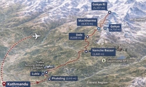
Route Map for Gokyo Lakes Trek — 14 Days
Frequently Asked Questions
Trails are not technical, but long days and higher camps above 4,000 m make it physically demanding. Pace slowly and take the acclimatisation days seriously.
Most do 10 to 13 days including the Lukla flights and a rest day at Namche. A 13 day plan gives breathing room for weather and easier acclimatisation.
The main high point is Gokyo Ri at about 5,357 m. The sunrise panorama from the ridge is to die for.
You need the Sagarmatha park permit and TIMS. The route sits inside Sagarmatha National Park; Nepal Royal Treks will arrange permits before you leave Kathmandu.
From the main viewpoint you can see pick out Mount Everest among the skyline along with Lhotse and Cho Oyu.
The stay is usually Teahouse style. Expect twin rooms, shared bathrooms, a wood or yak dung stove in the dining room, and simple hot meals like dal bhat and soups.
Yes. It is common to link over the Cho La Pass into the Everest Base Camp trail. That usually adds 2–3 days and more technical walking. We, Nepal Royal Treks will plan the extension safely.
If you are not used to travel or trek in higher altitude, it can be a concern. . Follow the itinerary, hydrate, eat, sleep, and tell your guide immediately if you have persistent headache, nausea or breathlessness
Flights to and from Tenzing-Hillary Airport are weather dependent and often scheduled early mornings. Delays or backups occur in poor weather, so sensible itineraries will include buffer days or flexible return plans.
Yes. Travel insurance that covers high altitude trekking and helicopter evacuation is strongly recommended.
Warm down jacket, layered clothing, waterproof shell, good boots, sleeping bag for subzero temps, tons of socks, trekking poles and sun protection. Make sure to Pack light but bring rain and cold protection.
The route passes through forests, glacier valleys and alpine terrain where trekkers sometimes see Himalayan thar, musk deer and high altitude bird species.
You may also like