The Best Viewpoints in the Langtang Region
You may have been at the brink of a mountain trail and had your heart pounding and your lungs full of mountain air before the sunrise changed the snow-capped peaks to tawny and light pink, and you already know that you cannot capture some things on a camera. They have to be lived. The Langtang area of Nepal is shot through with them.
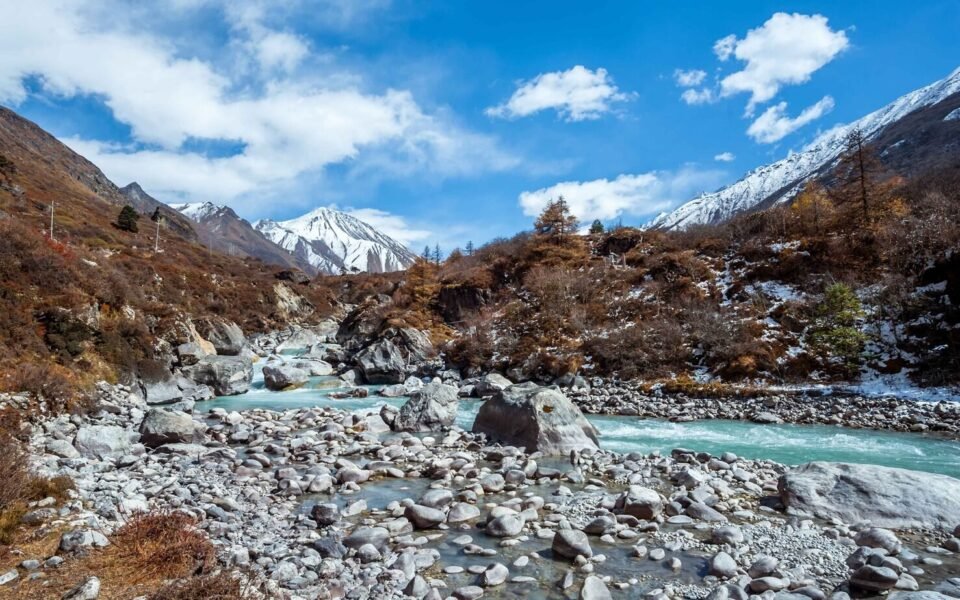
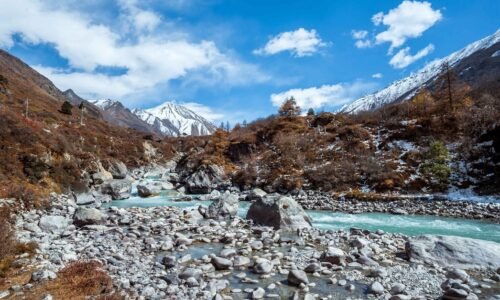
Secluded in the north of Kathmandu and closer to the Tibetan border than most trekkers even anticipate, Langtang does not necessarily secure the headlines like the Everest Base Camp or the Annapurna Circuit. And honestly? It is one of the reasons why it is so special. The paths are like a secret that has not been fully unraveled yet. You will walk through rhododendron forests so thick that you can neither see the sky nor the river bridges that vibrate underfoot with good health, and at night, spend time in teahouses where dal bhat is diligently prepared with devotion.
However, it is the perspectives that attract more people to Langtang than the day-to-day magic of trekking, and it is these perspectives that make people come back again and again to Langtang—the locations where all that walking will then culminate in something to open your mouth.
Here, we will take you through the most suitable perspectives in the Langtang Part. You will hear what each of them is worth the trouble, what you will find on the journey, and how you will organize your trip to have the best possible experience. It can be your first serious outdoor outing in the boots or make you an old-world veteran of the high-altitude trek, and is packed with the beginner and the expert alike; in any case, one of these perspectives will transform the vision of the world forever.
Why the Langtang Region Deserves More Credit
We will discuss the particular opinions, but before doing so, it would be good to discuss why Langtang has been criminally underestimated as a trekking destination.
The majority of flyers into Kathmandu find themselves swayed to the standard lines of the Everest or the Annapurna. Those are something remarkable, of course. But Langtang has some of the things that the routes cannot compete with. First of all, it is much closer to Kathmandu. The trailhead at Syabrubesi can be approached with a seven- to eight-hour road torture compared with what most people take by flight to Lukla to Everest. The fact that it is very convenient when dealing with a few vacation days.
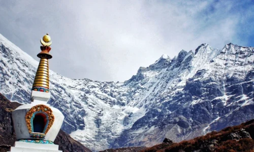
The area is also, plainly speaking, more personal. The Langtang Valley is narrower, greener, and less noisy. Taman and Tibetan residents who inhabit it have preserved their ways that seem genuinely attached to the land, as opposed to the development of new ones to attract tourism. You will be able to see prayer flags hung over the suspension bridges and hear the butter being thwacked in kitchens of teahouses.
There is one national park, Langtang, including the trekking territory, home to red pandas, Himalayan tahr, snow leopards (not very common, but they still exist), and a recently surprising amount of different bird species. The trip would be justified by itself by the biodiversity. But there you add the mountain views, and you have something absolutely difficult to duplicate anywhere in the world.
The earthquake in 2015 devastated the area, especially in Langtang Village, where the whole village was even covered. The town recovered, and coming here now was also giving a part in the current resurgence. The individuals you interact with, the guesthouses you are staying in, and the food you dine on—it all gives nourishment to a region that has attained its resiliency through difficult means.
Now, let’s talk about the views.
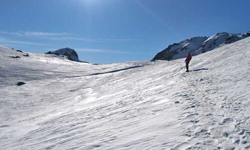
1. Kyanjin Ri—Where the Himalaya Finally Reveals Themselves
When you are choosing between only one perspective of the Langtang Region, then most of the experienced trekkers who come here can advise you to visit Kyanjin Ri. It is not the peak you can reach, but one of those spots where you are all of it, the scale, the color, the silence come together so that you know squarely that you are the best minuscule human being you can be.
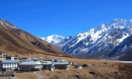
Kyanjin Ri tops Kyanjin Gompa, which is the tallest of settlements in the Langtang Valley at approximately 3,870 meters. The ascending trip of the village to the peak of Kyanjin Ri is a two- to four-hour walk, depending on your speed and the condition of the vegetation trail. You will have a mile or two of ups and downs with alpine pastures in spring, laden with wildflowers, and then just more and more rocks with their air thinning out around you.
The path is not really strenuous, with no permanent ropes or bluffs to climb, but the elevation will put you down in a hurry when it comes to rushing. Take your time. Look back down the valley. Let your lungs adjust. It will not have disappeared before you get to the mountain.
And when you do arrive– when you rise that last ridge and the landscape is stretched out before you—then it is one of those moments when you automatically shut up. The peak of Langtang Lirung at 7,227 meters takes up most of the scenery, with its ice-laden flanks being so near you can identify individual crevasses. Dorje Lakpa rises to the east. Downpour down glaciers as they spill over ridges that appear nearly impossible to climb. The mountains form the horizon in all directions.
The 360-degree perspective of Kyanjin Ri is really incredible. A majority of the perspectives provide you with an outlook on one side of the range. This one immerses you into it, into the midst of it. Photographers will prefer to go to shoot sunrise—the light is variable and dramatic, starting as a cold blue shadow and moving through warmer amber to blind white within the span of half an hour. Get here as early as you can, before sunrise, and bring every layer of clothes you can imagine you shall need.
You do not have to be a photographer to have the kind of experience of having been sitting at Kyanjin Ri during the sunrise of the day and find years later still in a conversation, still clear in the mind.
What to know before you go:
As to the approach to Kyanjin Ri, we need a base at Kyanjin Gompa, which in turn would cost three to four days of walking on foot beginning at Syabrubesi. Allow Kyanjin Gompa to have at least one acclimatization day before trying to climb. The peak is situated at approximately 4,773 meters in elevation, and thus, altitude sickness is a real issue. Take your time, take water in between, and do not be too proud to turn back in the midst of things once your body sends you a signal.
Spring (March to May) and autumn (October to November) are the best seasons. In winter, the top parts are not so safe with snow, and the monsoon time (June to August) is filled with clouds and leeches, which is not such a good mix.
2. Tsergo Ri—For Those Who Want to Go Higher
In case Kyanjin Ri is the point of view of everybody, Tsergo Ri is the point of view of people who should go a bit further. Being located at about 4,984 meters, it is one of the highest available platforms in the whole Langtang Valley, and the rewards one gets are equal to the efforts one puts in accessing the site.
It would take most of the trekkers four to six hours round-trip as they make their way up the whole way to the Tsergo Ri, beginning at Kyanjin Gompa. It is very steep, especially towards the topmost parts, and the thin air at almost 5,000 meters would imply your legs are actually pulling far more efficiently than the gradient would imply back in the seas. However, the path is relatively clear-cut, and during a clear morning, you will likely have other pilgrims who are undertaking the same journey.
The only thing that is particularly outstanding about Tsergo Ri is the sheer mass of the panorama. When it is not cloudy, on such a clear day, when the autumn sky in Langtang can be crystal clear, it is possible to see Everest. It is far off, but undoubtedly that dark pyramid is sticking up above the horizon southeastward. Ganesh Himal looms in the west, with Shishapangma (one of the eight-thousand-meter giants) barely across the border in Tibet looming to the north. It is one of those few places in Nepal where you can view the peaks of three different major ranges in a single sight.
Probably even more dramatic than Kyanjin Ri, however, is the Tsergo Ri sunrise, in part since you are higher and in part because the horizon is broader. The initial light illuminates the highest points first, and the remaining areas in the valleys are still shadowy. After a few minutes, it appears that the mountains are in the dark. It is like a dream of a photographer and a totally impossible thing that cannot be described enough with words, which is, of course, the main purpose of going.
Tsergo Ri does not come easy and without the right amount of fitness and acclimatization. Do not attack it on your first full day in Kyanjin Gompa. Make sure there is no rush to the higher altitude and spend at minimum a day or two at the lower altitude before going higher, as a warm-up to Kyanjin Ri. In case some of the symptoms of altitude sickness, like a headache, nausea, dizziness, or shortness of breath other than normal exertion, set in, then descend the mountain rather than climbing it.
A few practical tips:
Begin climbing the mountain early enough—before 6 AM. The atmosphere at high altitude Himalayan areas has a tendency to worsen at the beginning of the afternoon when the clouds roll over and block the vision you took hours of climbing to observe. It also means that you can arrive in Kyanjin Gompa before the cold has truly set in. It is also good to bring warm gloves, a hat, sunglasses, and even sun protection since at the altitude the UV light in the air is intense even though the air itself is cold.
3. Langshisa Kharka — The Alpine Meadow That Stops You in Your Tracks
Other perspectives will require all you have to give: an early alarm, a chastising ascent, aching lungs. Something different is asked by Langshisa Kharka. It asks you to slow down. Located approximately 4, 250 meters east of Kyanjin Gompa, Langshisa Kharka is a wide expanse of alpine grassland with the Langtang Valley opening and the mountains merely pilling round you. Nothing major to hog the limelight in terms of his dramatics. Instead, you have Langshisa Ri, Gangchampo, and Dorje Lakpa so that they put their places on the horizon like they been anticipating your arrival. The meadow is bounded on each side by two glaciers, Salbhachum to the north and Langshisa to the south. It is an odd experience standing between them, on grass soft enough to sit on.
The walk from Kyanjin Gompa to the Kyanjin Gompa requires a period of four to five hours on a path that slowly passes through rocky meadows and barren land. The lack of permanent teahouses at Langshisa Kharka implies you will need a camp; however, it also marks that you will carry all the equipment along and, as such, that this will most likely leave the place pretty much to yourself. That is a trade-off that is worth it. The night you wake up, 4,250 meters uphill in a tent surrounded by glaciers within reach, and the sky brimming with stars, is the type of night that you recall, unlike when staying at a hotel. The perspective is what makes Langshisa Kharka special as a point of view. You are not looking down on the world as Kyanjin Ri or Tsergo Ri was.
You are not high on top of mountains, you are on the same plane as the mountains. It is a horizontal connection to the Himalaya, which happens to feel quite intimate. Yak herders bring their kine, and you will at times find them in a small herd. It is an alive, working quality that makes the place seem real in a manner that only pure scenic locations do not. Spring and autumn both bring deliverance. Come either season – just come.
4. Laurebina Pass — The Crossing That Shows You Two Worlds at Once
The majority of the perspectives are destinations. You go, you look, you come back. That is not the case with Laurebina Pass. It is a bridging place of sorts, a crossing place, 4,620 meters high, with the Langtang Valley on one side and the sacred Gosaikunda basin on the other from which the Langtang Valley leads to the basin, and the Gosaikanda basin leads to the Langtang Valley, and yet, the view in every direction extends far so that you can hardly believe what you are viewing until several minutes, remember, have lapsed.
The view across the Laurebina Pass is truly one of the most extensive in the whole part. To the north can be seen Langtang Lirung. Ganesh Himal supports the west. When the sky is extremely clear in autumn, on very distant days, the range of Annapurna can be seen in the far environment, which is almost unbelievable since it is so distant. A passage south of the pass leads down to the Gosaikunda Lakes, receiving the light of which are these high-altitude sacred lakes, at which Hindu pilgrims visit some time annually on Janai Purnima. It is the mountain spectacle coupled with cultural meaning that provides Laurebina with the depth that cannot be fully provided by pure scenic viewpoints.
It can be approached by going up Thulo Syabru via Sing Gompa, or as a component course of the larger Langtang-Gosaikunda circuit – one of the most desirable routes of longer length in Nepal. It is a mountain that is ascending, and the height is respectable. Poles indeed come in handy, especially the down, which is taxing on the knees. Early start, dress up warmly, and be aware that everything can change in the weather quickly above 4,000 meters. But this is what you are not told, until you are up there, and that is that what you get on the approach trail is reward before anything you get on the pass.
Open views, rhododendron forests yielding to bare rock, teahouses, in which the owners will be happy to inform you about the conditions of the mountain ahead, should you inquire. Laurebina Pass is not merely an opinion. It is an encompassing experience and is not only culturally rich but also overwhelmingly visual as well as unforgettable.
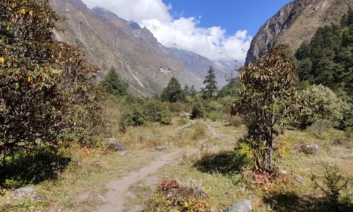
5. Ghodatabela Viewpoint — Where the Ecosystem Tells Its Own Story
Ghodatabela is located within the Langtang National Park itself, and it occupies a slightly dissimilar position to the other perspectives in this list. With Kyanjin Ri and Tsergo Ri being more or less about the mountains themselves, the drama of mountains and glaciers, the sky, etc., Ghodatabela is more about the entire. The woods, the plains, the towns, the wild animals, and the mountains are the setting of a living ecosystem instead of the primary focus.
The perspective can be arrived at in the lower parts of the trek, usually on the second day, at the place of the nights out of Syabrubesi. The contrast between the landscape here and in the high Alps, north of Kyanjin Gompa, is great. The timber is green, thick with bamboo, rhododendron, and oak. It happens often that the mornings in the valleys have mist which imparts to the view something of the effect of peep shot at a landscape picture with the middle ground gradually fading off to a soft grey, and the foreground shifting in and out of view with the breezes.
Ghodatabela perspective gives one an idea of how the Langtang Valley is physically arranged so as the river cuts through the lower part of the valley floor, the way the villages are built up at the right height to take the sun and avoid the worst of the valley cold, and how the trees in the forest thin out as one looks up the valley to expose bare rock and permanent snow. It is an outlook that makes you see the place not merely as a background, but also as a system.
This is also one of the most suitable places in the region where wildlife is observed. Red pandas, which are elusive and seem to be a strange crossbreed of a raccoon and a bear, live in the Langtang National Park, though are infamously hard to see. Pepper in the bamboo-grown regions around Ghodatabela in the mornings or evenings is the times which stand the best chance of success. Himalayan tahr – the shaggy, squat mountain goats that appear to be totally indifferent to slopes which would cause most humans to shudder onto the protrusions of the rocks above the tree line are more frequently found upon the outcrops of rock well above the tree line.
The Langtang River, upon which you have been stepping so frequently all the way down the trek, is seen on one side at Ghodatabela, a milky blue and fed up-stream by glacial melt. It is neither the wonderful beauty of high altitude vistas below, but of a different kind.
Good to know:
Ghodatabela should be looked at as a rest-stop instead of a point of arrival. Plan this trekking day as a trip to this place so that you can pull up and spend some time watching the scenery of this place, and allow the ecosystem to show itself gradually. Sightseeing on the journey up the mountain is one of the most frequent errors that leaves the trekkers with the idea that they had missed something, but not quite knowing what.
Planning Your Trek: Practical Things Worth Knowing
It is one thing to have an insight into the viewpoints. It is then another thing to arrive there in good condition and savor them. These are among the things to remember when planning.
There is a requirement for permits and entry fees in Langtang National Park (TIMS card along with national park entry permit). They can be organized in Kathmandu easily, before you set off yourself, and your trekking agency or guesthouse can assist you, or you may simply walk down to the Nepal government offices, which are just outside Thamel.
Guides and porters are not technically necessary in Langtang as they are in certain restricted paths in Nepal; however, the hiring of local guides is not only useful but also ethical. An excellent guide not only knows the path; he or she can predict when the weather is changing, which tea house is worth visiting, and also interpret the signs of the altitude that give them a clue when they should continue or have a rest. Carrying loads will not be your task; the porters will do such work, and you will be able to see the mountains and not look at your shoes.
Handy Teahouse can be found all over the Langtang trek. You do not have to bring a tent and camping equipment unless you desire to. The teahouses are plain though relaxed – bed, blanket, meal, and generally, a wood stove in the parlor which turns into the pharaoh of the night. Reservation is not a mandatory need except when you are already on a peak in-season, but it helps to secure a guarantee, especially when you are making a reservation for a place to stay at Kyanjin Gompa.
Food and water, Dal bhat (lentil soup rice) is the common meal, and it is really good. It is also the most effective thing to consume in order to maintain trekking energy. Even in the highest teahouses, water must always be treated or filtered. Incidentals: Have a reusable bottle and purification tablets (water) or a filter.
The problem of altitude sickness should not be ignored. That old-time tip of walking tall and sleeping down and taking gradual steps up is there because it is true. Its maximum daytime increase in sleeping elevation is 300-500 meters above 3,000 meters. Rest days are not days of wastedness; they are those that enable you to get the perspectives in fine health.
The Best Time to Visit Langtang
The season has two annual trekking seasons in Langtang and is regular with the bigger Himalayan seasons: spring (March to May) and autumn (October to November).
Autumn is generally claimed as the season when mountain scenery is at its best. By October, the monsoon has swept out the air, and the skies are of a deep, unyielding blue, which renders mountain photography nearly an insult to the profession. The daytime temperatures are pleasant, and the nighttime temperatures are cold and bearable; the trails are not muddy.
The spring is a new beauty, the rhododendron woods in blossom, the days beginning to thaw, new life returning to the high woods. Mountain views are a little less sure during spring because the clouds over the south during afternoons, but in the mornings can be very fantastic.
There is cool weather in winter (December through February). Tsergo Ri and higher parts of Kyanjin Ri may become harder due to snow on the upper portions, and can be negotiated, but their trails are passable. Some teahouses close. When you feel lonely and are not bothered by the cold, there is a stark, beautiful winter trek in the Langtang.
The viewpoints in particular are not always good during the monsoon season (June through August), as the visibility of the enabling mountains is not predictable due to cloud cover. Their trails are, too, muddy and infested with leeches. That said, the valley is too green, and the waterfalls are dramatic, making it a worthy trade-off to some trekkers.
A Final Thought on Why These Places Matter
We are living in a world that provides us with everything more and more remotely. Mountains on our screens, sunrises through Instagram, second-hand experiences on screens, and necessary to watch through photos in stories of other people. There is nothing wrong with that, but there is also something that it cannot bring you.
Being on top of Kyanjin Ri when it gets to be sunrise, and you have the cold air in your lungs, and you have the rock solid under your feet, and you are looking at Langtang Lirung change in dark shadow to spitting blood as the sun gets out of the eastern ridges, that is yours in a way that a photograph never is. The altitude headache you forced yourself to get there, the dal bhat you had taken down the road at 5 AM, the guide who showed you a monal pheasant on the road, all that is a part of the viewpoint. What you see is not all that you see. It is the entire experience of coming here.
The best perspectives of the Langtang Region Kyanjin Ri, Tsergo Ri, Phaqing Ting, Ghodatabela, the dozens of unnamed ridges and passes between all provide something truly unusual, an opportunity to experience the size of the world, to perceive in an innermost and physical sense how big and ancient and cold and indifferent the mountains really are, and to get, in that experience, something that passes, very oddly, as peace.
Come prepared. Come curious. Go slow. When you come, the mountains will be there.
Planning your Langtang trek? An adventure guided by Nepal Royal Treks company is local and has the best knowledge of the area, which would make the difference between a good trip and an outstanding one. The correct guide is not only conscious of the location of the viewpoints, but when the light is most advantageously upon them– and that sort of knowledge takes years to acquire.