-
 Duration
24 Days
Duration
24 Days
-
 Difficulty
Challenging
Difficulty
Challenging
-
 Max Elevation
5670m
Max Elevation
5670m
-
 Group Size
1-10 Person
Group Size
1-10 Person
-
 Accommodation
Camping
Accommodation
Camping
-
 Start/End
Dunai/Dunai
Start/End
Dunai/Dunai
-
 Destination
Dolpo
Destination
Dolpo
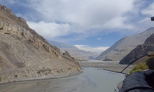
Dolpo region or valley is the most remote and one of the least developed district in Nepal. Dolpo region is situated between the plateau of Tibet and the Dhaulagiri Himalaya range. Since 1984, it has been the country’s largest national park and conservation which sustains a wide variety of wildlife including musk deer, Himalayan Blue Sheep and elusive Snow Leopard. It is also inhabited by the fascinating race of Tibetan speaking people. The wonderful adventure to upper Dolpo region begins encountering interesting places, villages, people, valleys and forest of pines, oaks, and rhododendron. The trek then passes many gigantic mountain ranges leading to the Phoksundo Lake at Ringmo village in the “Phoksundo National Park”.
The Himalayan range of Dolpo region can be seen in all its splendor and the view of Phoksundo Lake, surmounted by Rigma village provides the breathtaking view. Dolpo is an ancient kingdom of Tibet which lies in the northeast part of Nepal. The trek to Dolpo region is the trek from Jomsom to Juphal which crosses more than eleven mountain peaks, seven out of them are higher than 5,000m. Trek starts from Pokhara, the route then goes through high and remote alpine area and finally reaches to Do Tarap which is a beautiful village at high altitude. The trek then moves towards She Ghampa which will take to the beautiful premise of Phoksundo Lake, from here the trek will take a flight to return back to Kathmandu.
Why this trek is the Challenging trek?
The Upper Dolpo Trek is often regarded as one of Nepal’s toughest and most remote trekking areas, drawing only veteran trekkers who crave a genuine Himalayan experience. Nestled in the northwestern part of Nepal, Upper Dolpo is a nearly inaccessible isolated area close to Tibet. The difficulty of this trek is due to a combination of natural and logistical factors that distinguish it from popular trekking routes such as Everest or Annapurna.
One significant challenge of the Upper Dolpo Trek is the extreme remoteness of the area. The region has minimal road access, modern facilities, and communication networks. Trekkers have to depend on simple teahouses or camping throughout most of the trek. Due to this isolation, logistics like food supplies, accommodation, and emergency services are limited, which means that the trekker needs to plan and prepare carefully.
The high altitude is another great difficulty. The trail crosses a series of high mountain passes, including the Kang La Pass (5,360 m) and the Sela La Pass (5,094 m). Several days of walking above 4,000 meters dramatically increase the risk of altitude sickness. To complete the trek safely, trekkers require adequate acclimatization, physical fitness, and experience in high-altitude trekking.
Besides the long time required and rough terrain, Upper Dolpo remains physically exhausting. Generally, itineraries last between 18 and 25 days, and trekking is conducted each day on rocky trails, narrow mountain paths, and remote valleys. As the region receives little rainfall and lies in the rain shadow of the Himalayas, the terrain is mostly barren, windy, and, at times, harsh. Trekkers can walk for hours without encountering a village or facility.
Weather changes in Dolpo are often unpredictable, too. High winds, low temperatures, and sudden weather variations can make trekking more arduous, especially when crossing the high passes.
Nevertheless, Upper Dolpo presents an extraordinary and memorable cultural and natural experience. Trekkers find themselves immersed in the ancient Tibetan Buddhist culture, come across age-old monasteries such as Shey Gompa, and behold the breathtaking turquoise lake of Phoksundo. As the region is rarely visited by tourists, the trek allows for a truly genuine and tranquil Himalayan escapade.
For those who want to experience untouched nature, cultural richness, and real adventure, the Upper Dolpo Trek is undoubtedly one of the most challenging but utterly rewarding treks in Nepal.
Trip Highlights
- Follow the footprints of the ancient trans-Himalayan traders
- Explore the region in a dry weather without worrying about the rain
- Amazing time on this trek around the lake, Crystal mountain, and the views of Dhaulagiri
- Catch a view of diverse flora and fauna in the Shey Phoksundo National Park
- Get an insight into the life and culture of the followers of Bon Buddhism
Upper Dolpo Trek ( 24 Days ) ~ Itinerary
Day 1
Kathmandu to Nepalgunj (Flight)
- Altitude of Nepalgunj – 150 m (A flight of 50 minutes)
- Stay: Tea House
After breakfast, your guide will come to your hotel to pick you and will take you to the domestic terminal of Tribhuvan International Airport. You will then take a short flight to Nepalgunj.
Nepalgunj which is located in the western part of the Terai, the lowland area of Nepal is a little border town with India. Since there is a border crossing to India, the town feels like a blend of Nepal and India. After having dinner, you could explore some temples and other places in the area.Your guide will talk about the next days of the journey during dinner.
Notes: The schedule of flights may change depending on weather conditions.
Day 2
Nepalgunj to Jhupal (Flight) to Dunai
- Altitude: 2,850 m
- Walking: 3 hours
- Flight: 45 minutes
- Sleeping: Tea House
After breakfast, you will be taken to the airport to take a flight to Jhupal in the morning. You have left the Terai and, now, you are entering the mountains.
After coming to Jhupal, you will see the porters and the camping crew. Enjoy a cup of tea and a biscuit before the start of the journey.Today the walk is not hard but it will lead you on a trail that goes up past the Thulo Bheri Valley and through the fields of the village of Kalagaunda. You pass the Roop Ghar village that has a traditional water mill, then follow the river and, finally, reach Dunai.
Note: These timings are only a rough estimate and can be changed depending on the pace of trekking and trail conditions.
Day 3
Dunai to Ankhe
- Altitude: Height: 2,896 m
- Hiking duration: 6 hours
- Resting: Tea House
You will be traveling through the Thulo Bheri Valley and then through the Phoksundo River Valley, beginning with a steep climb out of Dunai. The hike will take you up and down a lot. One of the ups is to a ridge with a nice sight of Kagmara Peak which is visible further up the valley. There are also small villages to be traversed: Dhera famous for its walnut groves, and Rahagaun famous for its gompa which is dedicated to village guardian – Mastha.
You will then descend a canyon where the forest is very dense and cold. After that, a river crossing, and finally reaching Ankhe village.
Note: Around Ankhe, the trek entails steep climbs and declines.
Day 4
Ankhe to Sulighat
- Altitude- 3180 m
- Walking time: 6 hours
- Accommodation: Camping
After breakfast, you will go down the path where you can see the juniper and pine trees and cross a wooden bridge to come up again through the valley which offers you a wonderful view of the mountains. Besides, when you reach the highest point, you will get a wonderful view of the valley below.
There is a checkpoint at Silughar where your permits will be inspected. After that, you have truly entered Shey Phoksundo National Park! This is your first camping night here.
Note: The trekkers have to show their permits in this place before the continuation of the journey toward Phoksundo Lake.
Day 5
Sulighat to Phoksundo
- Altitude: 3,180 m
- Trek time: 6 hours
- Accommodation: Tea House
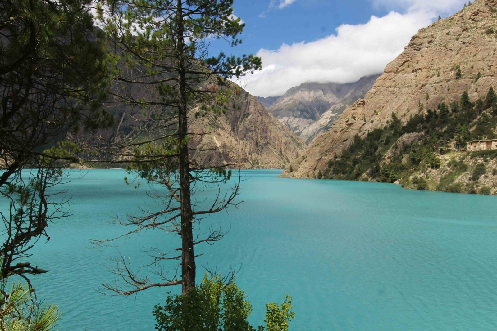
Today’s trek is the main highlight of the entire trip – you will finally arrive at Phoksundo Lake!
You will also witness the meeting of two rivers today – the Phoksundo and the Pungmo rivers. You will also get a glimpse of the Phoksundo waterfall, one of the highest waterfalls in Nepal. From here there are spectacular views of the lake itself.
On the way many we be passing through Ringmo Village, which is the nearest settlement to Phoksundo. This small village has mani walls (walls made of stones with Buddhist mantras carved into them) and chortens (stupas) to indicate to everyone that the residents practice Tibetan Buddhism.
At this point you will have your permits checked one more time as you are now about to enter the Shey Phoksundo National Park which is visible ahead.
Tonight, the camp will be near the Phoksundo Lake set with its turquoise waters. What a scene!
Note:Swimming or bathing in the lake is prohibited as it is a sacred site.
Day 6
Acclimatization Day
- Altitude: 3,612 m
- Tea House Accommodation
The setting of the campsite is absolutely perfect for having a relaxed breakfast. For the more active ones among you, it is possible to go on a short hike to Ringmo village to get a better view. Alternatively, you can just relax and take in the surroundings by doing a bit of yoga or meditation. Imagine the meditation in such a beautiful place!
Are you aware that Dolpo and Phoksundo Lake were featured in Eric Valli’s 1999 film ‘Himalaya’?
Set in a fictitious village, this movie, which is quite true to the local way of life at various points, centers around the caravans of yaks used by the villagers who take the mountains to transport salt for grain trading in the lowlands.
Furthermore, the film illustrates the feud between the tribe chief Tinle and a young herdsman, Karma. And as it turns out, Tinle dies in the mountains due to a snowstorm. Norbu, his monk son, decorates the monastery wall with the scenes of the caravan’s journey to honor his father.
However, while the two lead actors, Gurgon Kyap as Karma and Lhakpa Tsamchoe as Pema, the female lead, come from outside Nepal, Thinle Lhondup, who played Tinle, was actually from Dolpo and had never acted before.
Disappointingly Thinle passed away in Dolpo in 2016 – presumably in the way he wished. Also, mention the numerous other locals who appeared in the film and Nepal’s very own Jampa Kalsang who has starred in many other films since.
Notes: This could be a day to use to rest, relax, explore Ringmo village, or simply bask in the beauty of nature.
Day 7
Phoksundo to Phoksundo Khola Camp
- Altitude: – 3507 m
- Trek time: 5 hours
- Camping Accommodation
- Elevation: 3,507 m
Follow the eastern shore of Phoksundo Lake first thing to get to the point where you start a relatively flat trail along a riverbed. Once there, you will come across meadows mingled with giant boulders. The perfect combination of the magical lake closed by your side, and Kanjirowa Himal looming above, makes this day one of the great treks.
Camping facilities are very basic, no teahouses on the trail – make sure you have enough supplies.
Day 8
Phoksundo Khola Camp to Phoksundo Bhanjyang
- Altitude – 3,910 m
- Trek time: 6 hours
- Camping Accommodation
The hike today starts with the gradual climb up a narrow path taking you through a glacier valley. You will be able to cross the mountain streams that you keep coming across several times throughout today’s hike until eventually, there is the long climb to the green pasture which you will use to cross to another valley (via a climb) with views of Kang La Pass and peaks such as Chhamlang.
The route up to Phoksundo Bhanjyang is steep and rugged; good physical condition is necessary.
Day 9
Phoksundo Bhanjyang to Shey Gompa
- Altitude– 4500 m
- Time: 6 hours
- Stay: Camping
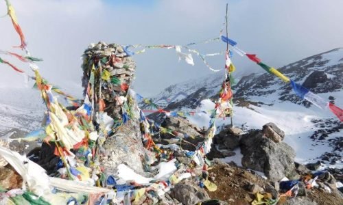
On the day after breakfast you are going to go up the Kang La Pass at 5,350 m / 17,552.4 ft, one of the challenging days on this trekking.
You can expect a very hard day on the trek when you look at the view of the wonderful overall panorama from the prayer flag covered pass.
The path down is going to be very steep at first and then as you get nearer to Shey Gompa, the slope is going to be more gradual. The village is really small with just a few houses but the monastery, which is the main attraction, is enough to get you there.
Legend has it that Shey Gompa was erected when a Buddhist came to the place riding a flying snow lion to fight with a local mountain spirit. Shey Gompa was built exactly where this battle took place. Nearby is Crystal Mountain.
Note: It is of utmost importance to get acclimatized properly because the high altitude and the difficult terrain make it a bit risky to reach this holy place.
Day 10
Acclimatization Day
- Altitude– 4500 m
After having breakfast, if you want, you can roam around the area as well as climb the Crystal Mountain.
As Shey Gompa is the most well known monastery in Dolpo, the neighbouring Crystal Mountain is spiritually important for the Buddhists.
The mountain’s from the quartz veins were named by the bases of the mountain quartz mineral which shines in the sunlight.
The whole moon in July/August is known for the devotees circling the mountain. It is an amazing moment for a visit if you want.
Note: Due to the high altitude it is advisable to stay away from any establishments. Avoid accessing dehydration that can cause serious health problems.
Day 11
Shey Gompa to Namduna Gaon
- Altitude – 4800 m
- Time: 6 hours
- Stay: Camping
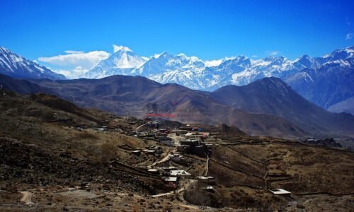
This day, you get to see the Tibetan Plateau to the north from the summit of a pass. If you turn your face in different direction, you will get the clear view of Mustang region which is towards east in Nepal.
You have been climbing above the past time, now you are going down into the grassy areas and farmland that are located around the Nam Gaun Gompa. Along with these fields, there are nomadic tents composed of yak hair in the pastures where the herders are grazing their yaks and sheep.
There is one more gompa, Namduna Gaun, where you can go and compare with the other ones that you have visited.
Note: Walking to Namduna Gaun would involve steep climbing and rough surface.
Day 12
Namduna Gaon to Saldang
- Altitude – 3620 m
- Trek time: 5 hours
- Accommodation: Camping
Today your main goal is to ascend the valley and from there you will be able to see highly workable land. After that, you will head down to Saldang.
Saldang is the largest community in Inner Dolpo located in the dry trans-Himalayan zone. It is not one but five settlements set out on a large slope. Saldang has been quite a prosperous village considering that it is positioned on the trade route between Tibet and Nepal. And it is still an interesting village to experience.
Note: The pathway to Saldang is quite difficult, so proper acclimatization is a must.
Day 13
Saldang to Yangze Gompa
- Yangze Gompa – 4960 m
- Trek time: 4 hours
- Accommodation: Camping
Today you’ll only be making a short jaunt along a deserted track at the side of the Nagon Khola (river). On the way, you will pass through Marang and Ki villages, cross Panzang River, and then arrive at Yangze Gompa.
Yangze Gompa is believed to be over a millennium old. It really gives a sense of its long history from the size and the large number of chortens (stupas).
Spend a little while here, discover the gompa, and if you can, attend the monks’ evening prayers.
Note: The route to Yangze Gompa is quite steep and the surface is rough, so the climb requires a good physical condition.
Day 14
Yangze Gompa to Sibu
- Altitude – 4560 m
- Trek time: 6 hours
- Accommodation: Camping
Dolpo has many gompas that you have already seen, but today your trek to Sibu will take you past more gompas.
This evening you will be camping by the river at Sibu, yet another amazing spot to enjoy sleeping outside while being surrounded by nature.
Note: The path to Sibu is quite easy, however, the next day’s hike involves a steep climb up Jeng La Pass.
Day 15
Sibu to Jeng La Phedi
- Altitude – 4900m
- Trek time: 6 hours
- Accommodation: Camping
Jeng La Phedi means ‘Jeng La Pass base’. As you may guess, you will reach the base of this pass today because it is the one you will be climbing over tomorrow.
Following Nagon Khola (river) you may come across yak caravans on the trail as they are heading to their grazing grounds. Overall, today’s itinerary is rocky hills at high altitude with strong, cold winds.
Fortunately, after the day’s journey you can look forward to some hot tea and dinner at the camp site.
Note: The way to Jeng La Phedi is steep and rocky in places so make sure your physical fitness and acclimatization are really good before you attempt the pass.
Day 16
Jeng La Phedi to Tokyu Gaon via Jeng La Pass
- Altitude – 4209 m
- Trek duration: 7 hrs
- Accommodation: Camping
This is one of the days in which you will set foot on the Jeng La Pass which is at an altitude of 5,150 m / 16,900 feet. Even though the ascent to the top (about 2 hrs) is not long, it is quite steep and going to the high altitude makes it more difficult. The view from the top of the Jeng La Pass showed the west side of the snow-capped Dhaulagiri massif which took one’s breath away.
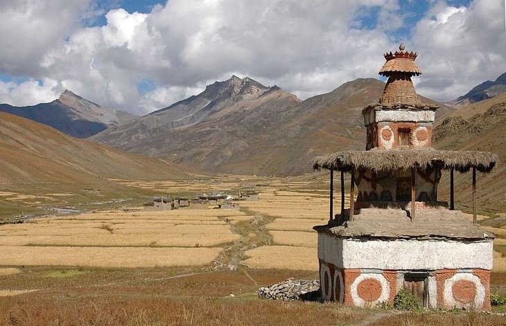
Keep on the descent towards the Tarap Valley whose flat lands and the running Tarap Chu (river) represent the beauties of life there. There are roughly 10 villages scattered over this flat land with each village having not only its cultivated fields but also the gompas and chortens.
Note: Trekkers should be prepared for a rustic experience and carry necessary supplies.
Day 17
Tokyu Gaon – Dho Tarap
- Altitude – 4040 m
- Trek time: 5 hrs
- Accommodation: Camping
Right after breakfast, the group will visit Dho Tarap by walking through a mountainous valley along which the village is situated. This village of magars is really based on farming – buckwheat, barley, and potatoes are their food crops. Architecturally, the houses are mainly of traditional design heavily influenced by Tibetan style.
This village was the setting for the film ‘Himalaya’.
The populations here follow both the religion of Buddhism and Bon Po – the latter is the religion prior to Buddhism and also it originates from Tibet.
Note: It is an absolute must to get acclimatized before-hand so as to not get sick from altitude as it is a very high altitude.
Day 18
Acclimatization Day
Rest and relaxing are some of the things you can do today so you even have the chance to get an extra hour of sleep and eat a breakfast later than usual.
Afterwards, visiting the village will bring you to a Buddhist Gompa where you will be allowed to enter. You can also take a walk of about 30 minutes and get to a Bon Gompa. When you take a visit here you will be able to make a comparison between the two.
Bon is a Tibetan religion that is very much like Tibetan Buddhism and influenced by it but is still a minority in Tibet. Followers of Bon, claim that the religion was started in the kingdom of Zhangzhung, near the sacred mountain of Mt Kailash, and from that place it moved into Tibet.
A slight estimation of 2019 was that there were about 400,000 followers of Bon on the Tibetan plateau. Like Tibetan Buddhism, the Chinese cultural revolution resulted in a destruction of the approximately 30 Bon monasteries in Tibet (however they were permitted to be rebuilt after 1980). Currently, the spiritual leader of the Bon is Menri Trizin Rinpoche. Bon monasteries can be found in Nepal and Tibet.
Note: Prepare yourselves for an absolute off-the-grid experience as there will be absolutely no WiFi or mobile signal.
Day 19
Dho Tarap - Tarap Khola
- Altitude: 3800m
- Walking time: 6 hrs
- Altitude: Camping
Today you’ll be hiking down after leaving Dho Tarap via juniper bushes and wild roses. Once you are down in the wide valley, the sun will be setting on your face.
Along the walk, you will see the point where the Tarap Chu and Lang Khola rivers meet, and have a few switchback trails as you go down to Tarap Khola (river) where the vegetation starts to change from the pasture land to alpine vegetation.
Again you will set up your camp near a river – the ambiance being very peaceful and making your heart ache with joy.
Note: Along the Tarap Khola trail, you might have to deal with narrow paths, river crossings, and in some places landslides
Day 20
Tarap Khola to Khani Gaon
- Altitude: 3,150 m
- Approximate trekking hours: 5
- Accommodation: Camping
The trail will, in parts, follow the gorge of the river Tarap and its waters. Caution should be exercised while going over some stone stairs as some stones may be loosened which may pose a danger to you.
By lunchtime, you will have arrived and will have enough time to get to know the inhabitants of Khani Gaon if that is possible since this village receives more trekkers than the rest of the villages that you have visited on this if not one of the most unique treks at all.
Note: The landscape to get to Khani Gaon can be quite steep and difficult, there are some narrow paths and you will also have to cross the river a couple of times.
Day 21
Khani Gaon to Tarakot
- Altitude – 2,537 m
- Trek time: 5 hours
- Accommodation: Camping
First in the morning you will cross a suspension bridge, then the rest of your day will be following the river using trails that alternate between up and down. Also a little trickier is the day as maybe you will have to use stepping stones to cross the river at some points. They can be really slippery, so please be cautious.
More and more scaled and cultivated crops are seen as you get closer to Tarakot – a town centered around a fort. It was capital of this region even before the Gorkha dynasty was established. If you go a bit east from Tarakot close to Barbung and Tarap Chu rivers you will surprise Sandul Gompa. Actually, the Gompa used to charge tolls to trading caravans coming this way.
Note: The going to Tarakot consists of some steep parts and crossings of the river.
Day 22
Tarakot to Dunai
- Altitude – 2,850 m
- Trek time: 6 hours
- Accommodation: Camping
Most of your day will be spent going downhill. Then as you walk along the Bheri River you will be heading towards the end of this circuit trek.
Tonight, you can stay in a teahouse and enjoy the things you missed in the camp, like soft drinks and beer!
Note:While you make your way downhill enjoy the serene river sceneries and the surrounding mountains.
Day 23
Dunai to Jhupal
- Altitude: 2,320 m
- Trek time: 3 hours
- Accommodation: Camping
It is your last day of hiking but the last hour is a bit uphill one! Just to challenge you that you are no match for the Himalayas!
Once you get to Jhupal you might want to celebrate with even more soft drinks and beer!
Jhupal is a former Village Development Committee (VDC) in Dolpo district and is now part of the Thuli Bheri Municipality. With its scenic mountain backdrop, Jhupal is the main gateway to Upper Dolpo and a starting point for many treks.
Note: There are a few shops and teahouses and maybe even WiFi!
Day 24
Flight from Jhupal to Nepalgunj and Kathmandu
- Altitude: 1,350 m
- Flight time: 1 hour 30 min
Today the journey will be a short flight first to Nepalgunj then a change of flight on to Kathmandu
Trip Cost Includes/Excludes
Cost Includes
- Tent House accommodation during the trip
- 1 Night accommodation in Nepalgunj
- English spoken guide and cooking staff
- Porter according to your group size
- Kathmandu Nepalgunj Kathmandu by flight
- Nepalgunj Jhupal Nepalgunj flight
- Shey Phoksundo national park permit
- Restricted area permit
- Breakfast, Lunch and dinner while on the trek
- All government and local taxes
Cost Excludes
- International airfare
- Lunch and dinner in Nepalgunj
- Travel insurance – Compulsory
- All cold drinks such as alcoholic beverages, mineral water, Coke, Fanta, juice, etc.
- Personal shopping and laundry, phone, internet bill, etc.
- Hotel in Kathmandu
- Tips for our staff
Trip Photo/Video Gallery
You may also like