Tilicho Lake in Map of Nepal: Finding the High-Altitude Gem
Tilicho Lake is not the kind of place you “drop by.” It doesn’t sit near a road. Or a café. Or a viewpoint with a railing. It waits. It waits nearly at the height of 5,000 meters with air so thin it slows your thoughts.
Words too. People talk less up in Tilicho. Interestingly, sometimes they completely stop talking. Not just because of physical exhaustion, but the surreal landscape needs your utmost attention. The wind moves freely. No filters. No noise. This lake has a reputation. One of the highest in the world. Sacred. Remote. Difficult. All true.
Long trails. Rough terrain. And then quiet moments that stay with you longer than the photos ever will. This is not luxury travel. It’s raw travel. Honest travel. Tilicho Lake doesn’t try to impress you. It doesn’t need to. It simply exists. And somehow, that’s enough.
Tilicho Lake on the Nepal Map: Location, Setting, and Context
On the map, Tilicho Lake looks remote. Truth is, things go way further than that. It is located in Manang District, within Gandaki Province, Nepal. It lies about 220–230 kilometers northwest of Kathmandu. Around 150 kilometers north of Pokhara, straight-line distance. Sounds close. But it’s not. Mountains change everything. Valleys twist roads. Trails don’t go straight. Every kilometer takes longer than it should.
Getting there is not simple. Trekking usually takes 10–14 days. Depends on the route. Depends on how your body handles the thin air. Acclimatization is key. Skip it, and the mountains remind you quickly.
Most trekkers know the Annapurna Circuit. Tilicho Lake is a different story. You leave the main trail. Head into a more remote, tougher area. Fewer villages. Less road access. Rocky paths. Landslide zones. Exposed ridges.
That’s what makes it special. The isolation. The quiet. The feeling that you are somewhere the world forgot.
North of the main Annapurna trekking path, the lake rests in a quiet stretch of land.
The Annapurna Circuit is popular. Busy in peak season. The Tilicho Lake trail is quieter. More demanding. Once you leave Manang and head toward Khangsar village, the landscape changes fast. Green hills give way to dry slopes. Trees disappear. The trail becomes exposed and raw.
You can locate Tilicho Lake clearly using reliable map sources:
- Google Maps (terrain & satellite view)
https://www.google.com/maps/place/Tilicho+Lake
According to ACAP and the Nepal Tourism Board, Tilicho Lake lies within a fragile alpine ecosystem. This is why trekkers must carry permits and follow strict environmental guidelines. The land up here doesn’t recover quickly. Sometimes not at all.
On a map, it’s a dot. On foot, it’s a commitment.
Tilicho Lake Altitude
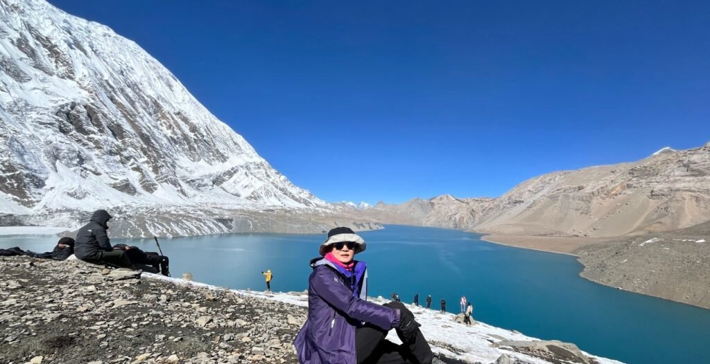
Tilicho Lake sits at approximately 4,919 meters (16,138 feet).
At this altitude, oxygen levels are significantly lower than at sea level. Even fit trekkers feel it. Walking becomes slower. Breathing louder. Headaches show up without invitation. Appetite disappears. Sleep gets strange.
Altitude sickness is a real concern here. And it doesn’t care how confident you feel.
That’s why acclimatization is essential. Most itineraries include at least one rest day in Manang village, often combined with short hikes to nearby viewpoints. This allows the body to adapt gradually. Skipping acclimatization is a mistake. A dangerous one.
Starting out from Kathmandu, travelers often take a bus or jeep ride to either Besisahar or Chame – routes shift based on how roads are holding up that season. Once arrived, boots hit the trail through parts of the Annapurna Circuit, though soon enough the path veers westward, aiming instead for Tilicho.
Manang village feels like a pause point.
Here, you’ll find places that bake bread. Hot coffee waits nearby. Now and then, there’s a signal floating through the air. People on the trek eat, rest, and share stories of their journey.
Beyond Manang, the path grows tougher, yet quieter too. The route toward Khangsar and Tilicho Base Camp passes through landslide-prone sections carved into steep mountain slopes. Sliced into sharp inclines, the ground has shifted here, made unstable by slides. Paths shrink tight, barely wide enough for one. Loose rocks. No railings. Guides often advise crossing certain areas quickly.
The barren landscape of Tilicho Base Camp feels almost unreal. No trees. No greenery. Just rock, dust, and towering cliffs. Lodges here are basic. Very basic. Thin walls. Cold rooms. Limited electricity. But there’s a shared focus in the air. Everyone here knows why they came. And everyone knows the lake is close. Sleep comes lightly. The wind rattles windows. People pack quietly before dawn for the big day tomorrow.
The final push to the Tilicho Lake begins early in the morning, usually before sunrise. The steady slope of a trail leads to the lake, surrounded by peaks like Tilicho Peak (7,134 m) and some parts of the Annapurna range.
Cultural and Spiritual Importance of Tilicho Lake
Tilicho Lake holds deep spiritual significance. In Hindu tradition, the lake is believed to be mentioned in ancient texts such as the Ramayana, regarded as a sacred water body associated with gods and sages. Hindu pilgrims visit Tilicho as an act of devotion, despite the physical difficulty of the journey.
Buddhists also revere the area, seeing it as a place of purity and meditation. Prayer flags flutter near the lake. Mantras echo softly when the wind moves right.Even if you don’t follow any belief system, the respect here is contagious. People lower their voices. Movements slow. It feels wrong to rush.
Best Time to Visit Tilicho Lake
Timing is everything in the Himalayas.
Recommended seasons:
- Spring (March to May)
- Autumn (September to November)
Spring offers clearer skies and blooming alpine landscapes at lower elevations. Autumn provides the most stable weather and excellent visibility. Nights remain cold in both seasons. Always.
Winter brings heavy snowfall, blocked trails, and extreme cold. Tilicho Lake often freezes completely. Trekking becomes risky.
Monsoon season increases landslide risk and reduces visibility. Not ideal. Often unsafe.
The weather changes fast here. Even on a good day. Always prepare for worse.
Permits Required for Tilicho Lake Trek
Permits are mandatory. No exceptions.
| Permit | Purpose | Issuing Authority |
| ACAP Permit | Entry into Annapurna Conservation Area | Nepal Tourism Board |
| TIMS Card | Trekker safety and tracking | Registered trekking agencies |
Permits are usually arranged in Kathmandu or Pokhara through registered trekking companies. They are checked at multiple checkpoints along the route. Carry them at all times.
Packing Tips for Tilicho Lake Trek
Packing poorly shows up fast at high altitude.
Here’s what matters:
| Category | Essentials |
| Clothing | Down jacket, thermal layers, waterproof shell |
| Footwear | Well broken-in trekking boots |
| Protection | Gloves, beanie, neck gaiter, sunglasses |
| Health | First-aid kit, altitude meds if prescribed |
| Hydration | Water bottle, purification tablets |
| Extras | Headlamp, power bank, snacks |
Pack light, but smart. Cold doesn’t forgive missing layers.
Practical Travel Tips That Actually Help
Some advice sounds boring. Until it saves your trip.
- Walk slow. Slower than you want.
- Drink water constantly.
- Eat even when appetite disappears.
- Listen to your guide. Always.
- Mobile signal is limited. Wi-Fi unreliable. Tell people back home in advance. The disconnect is part of the experience.
- And don’t rush the lake. It’s not going anywhere.
Accommodation and Food Along the Route
Teahouses provide basic lodging and meals. Expect simple food. Dal bhat. Noodles. Soups. Eggs. Tibetan bread.Keep in mind prices rise with altitude, and that’s normal in the mountains.
Rooms are shared, bathrooms are often communal, and hot showers are rare. Luxury isn’t the point here.
Is Tilicho Lake the Highest Lake on the Planet?
Well… not exactly, At around 4,919 meters, it’s insanely high. Most lakes don’t come close. But there are smaller lakes, glacial ponds, even seasonal water bodies that sit higher in other mountains around the world. So technically, Tilicho doesn’t hold the crown.
It all depends on how you define “lake.” Scientists look at size, permanence, and water source. Some lakes are tiny, temporary, and barely visible. Travelers usually care about altitude. Big, permanent, dramatic… that’s Tilicho.
And honestly, it’s enough. Standing there, looking at that wide, still water under towering peaks, does it really matter if it’s?
So yeah. Not the “world’s highest” in a textbook sense. But in experience?
Tilicho sits on the top.
Ready to visit Tilicho Lake?
Now that you know where Tilicho Lake is, getting there is another story. That’s where Nepal Royal Treks comes in. They handle all the logistics. Guides. Porters. Everything. You just focus on the trek. On the mountains. On the lake, Traveling alone up here is possible. But honestly? It’s not the same. Trails are tough. Weather changes fast. The mountains don’t wait for anyone. Having experienced guides makes it safer. They plan. You walk. They carry the load. You carry the experience. Because some places… some places are better when someone has your back. Tilicho Lake is one of them.
FAQs
1. Do you need a guide to hike to Tilicho Lake?
Not strictly. You can do it alone. But honestly… why risk it? Trails pass through landslide-prone areas. Remote sections. Confusing turns. A local guide adds safety. Even stories about the mountains and villages you’d otherwise miss.
2. Are teahouses available on the Tilicho Lake route?
Yes. Sort of. Don’t expect luxury. Basic teahouses stretch up to Tilicho Base Camp. Simple meals. Small rooms. Sometimes cold. But they exist. And after hours of walking, even a thin blanket feels like a throne.
3. Is drinking water easily available along the trail?
Sources exist. Streams. Springs. But untreated. Must be purified. Bottled water is rare and crazy expensive at high camps. Hydrate smart.
4. Is swimming allowed in Tilicho Lake?
No. Locals consider the lake holy. So, as a traveler, it is your responsibility to respect the place.