-
 Duration
17 Days
Duration
17 Days
-
 Difficulty
Challenging
Difficulty
Challenging
-
 Max Elevation
5416m
Max Elevation
5416m
-
 Group Size
1 to 10 People Person
Group Size
1 to 10 People Person
-
 Accommodation
Teahouse/Lodge
Accommodation
Teahouse/Lodge
-
 Start/End
Kathmandu Airport/Kathmandu
Start/End
Kathmandu Airport/Kathmandu
-
 Destination
Annapurna Region
Destination
Annapurna Region
-
 Best Season
March-May and Sep-Nov
Best Season
March-May and Sep-Nov

The Nar Phu Valley Trek is one of the most remote and culturally preserved trekking routes in the Annapurna region of Nepal.
Hidden north of the popular Annapurna Circuit between Koto and Manang, the valleys of Nar and Phu remained closed to foreign trekkers until 2002, which is one of the main reasons the region still feels untouched compared with Nepal’s busier trekking routes.
The trail to Nar Phu goes into a restricted valley of the Himalayas, and Tibetan Buddhist life, ancient stone villages, yak pastures and high mountain deserts still dictate the way people live today in much the same way as they did generations ago.
The 17 day Nar Phu Valley Trek starts in Kathmandu and then takes the Marshyangdi River valley to Jagat and Dharapani, passing through pine forest, deep river gorges and traditional Gurung villages in the northern Annapurna region.
On reaching Koto, the trail turns off the main Annapurna Circuit and enters the restricted Nar Phu valley through the dramatic valley of the Nar Khola and Phu Khola.
The change you feel is instant. The lower hills are gradually replaced by bare cliffs, narrow rock corridors, wide open valleys, and scattered Tibetan style villages nestled under immense rock walls of the Himalayas.
One of the biggest reasons trekkers choose the Nar Phu Valley Trek is because of how different it feels from Nepal’s more commercial trekking routes.
The villages in question, Meta, Phu Gaon and Nar are not modern tourist-oriented villages. These are ancient communities in the Himalayas where the families breed yaks, practice Tibetan Buddhism and follow mountain living routines throughout the seasons.
The path becomes more than just one that passes through stone mani walls, prayer wheels, chortens, ancient monasteries and high elevation grazing fields; it is a path which is taken everyday.
Even the teahouses are not as fancy and luxurious as are those of the Everest Base Camp or the lower Annapurna Circuit.
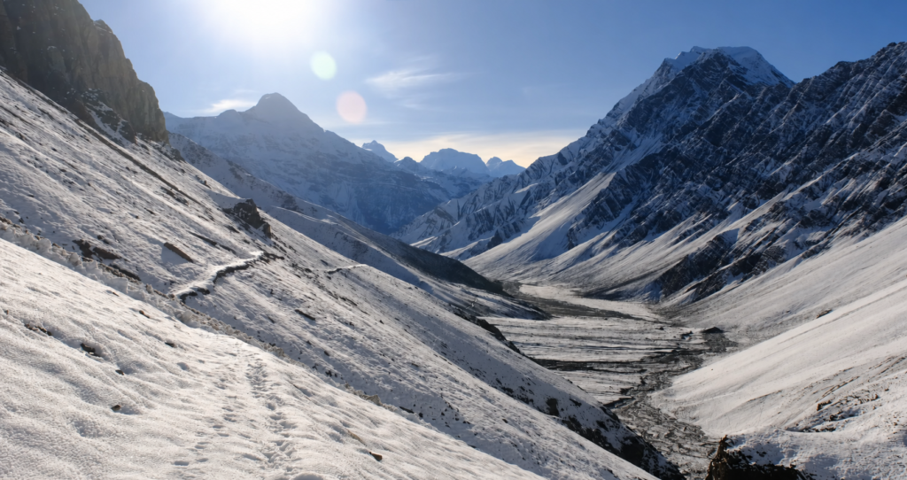
The trail itself is also much wilder than many trekkers would expect and is quite rugged. The section between Koto and Phu travels through one of the narrowest and very dramatic trekking trails in Nepal.
The hike continues to ascend into the upper valley as it enters a cold desert landscape, weathered by the wind, snow and glacial activity.
This is one of the best parts of the entire route and is a constant change of scenery, as each day is different from the next.
Throughout the trek in the Nar Valley, altitude is a very significant factor, particularly when you reach the village of Nar at 4110m.
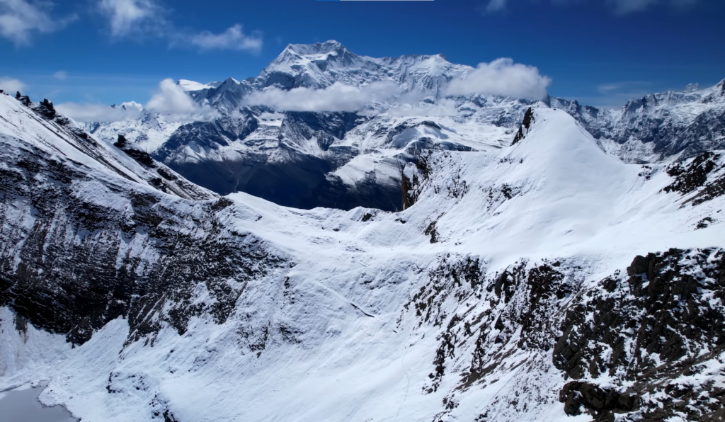
The route later passes the highest trekking pass in the Annapurna region, Kang La Pass at 5322m and proper acclimatisation is important.
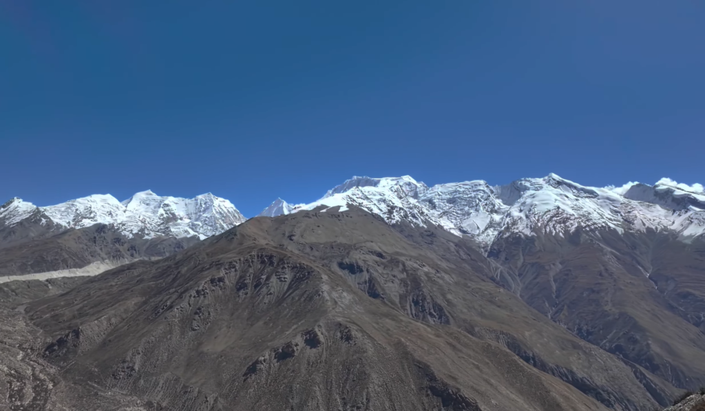
The hike to Kang La is quite strenuous but very rewarding, offering expansive vistas of Annapurna II, Gangapurna, Tilicho Peak, Chulu East, Manaslu and the rest of the Annapurna massif.
It follows the old Annapurna Circuit after coming out of the pass, leading to the village of Ngawal and then passes the Thorong La and joins the route to Manang.
The Nar Phu trek is significant because of the combination of two main passes in the Himalayas in one trip.
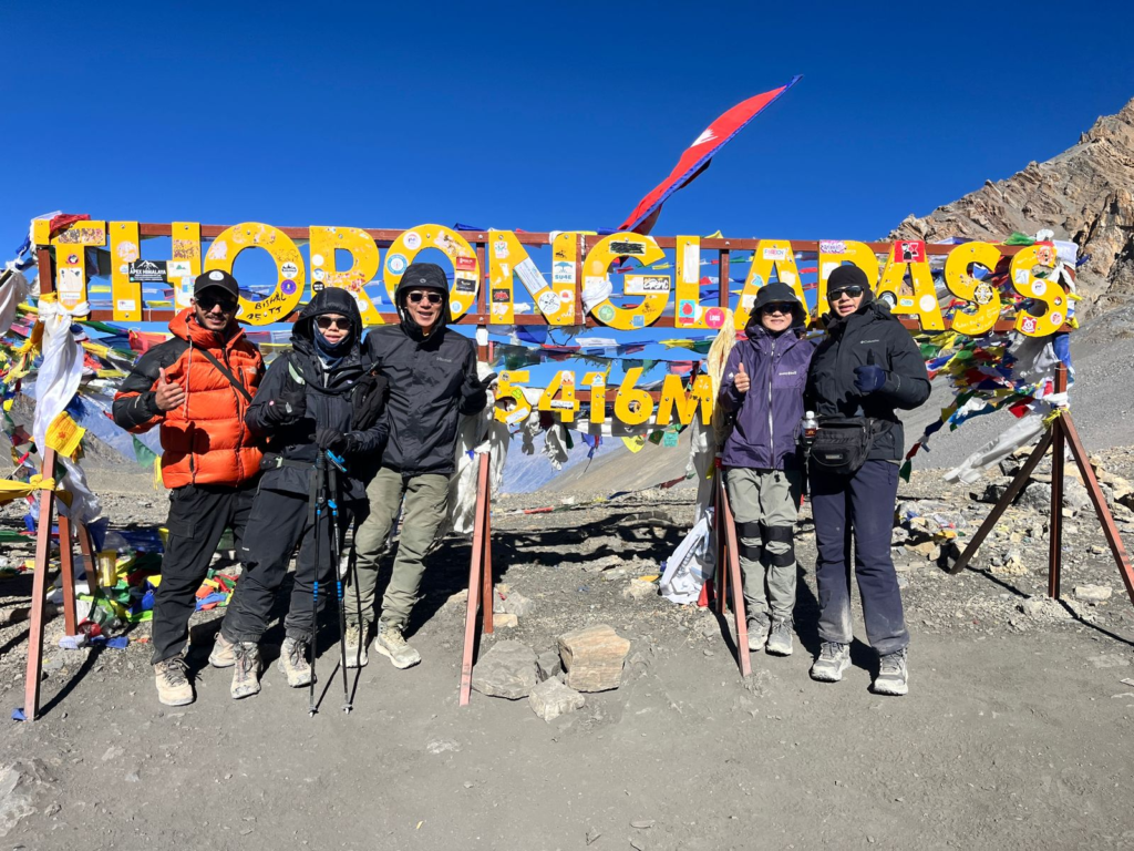
Once they have reached Kang La, trekkers head towards Thorong La Pass (5,416 m) to cross into Mustang region and Muktinath.
The second high pass adds to the adventure, as it is in the remote wilderness of Nar Phu and one of the most picturesque trans Himalayan passes in Nepal.
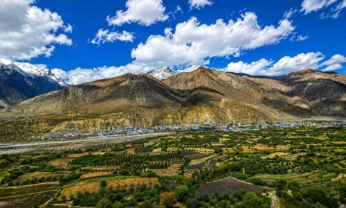
As you wind down from Thorong La to Muktinath, you’re once again in the dry land of Mustang, with cliffs, eroded hills, ancient monasteries and river valleys cut by the Kali Gandaki Gorge.
The overall experience of this trek has a strong contrast and completion as the valleys of Nar Phu are hidden and Muktinath has a pilgrimage feel to it.
Villages such as Nar and Phu preserve strong Tibetan influence in language, architecture, religion, and daily life.
Prayer flags stretch across rooftops, yak caravans still move through the valleys during seasonal migrations, and centuries old monasteries remain active community centers.
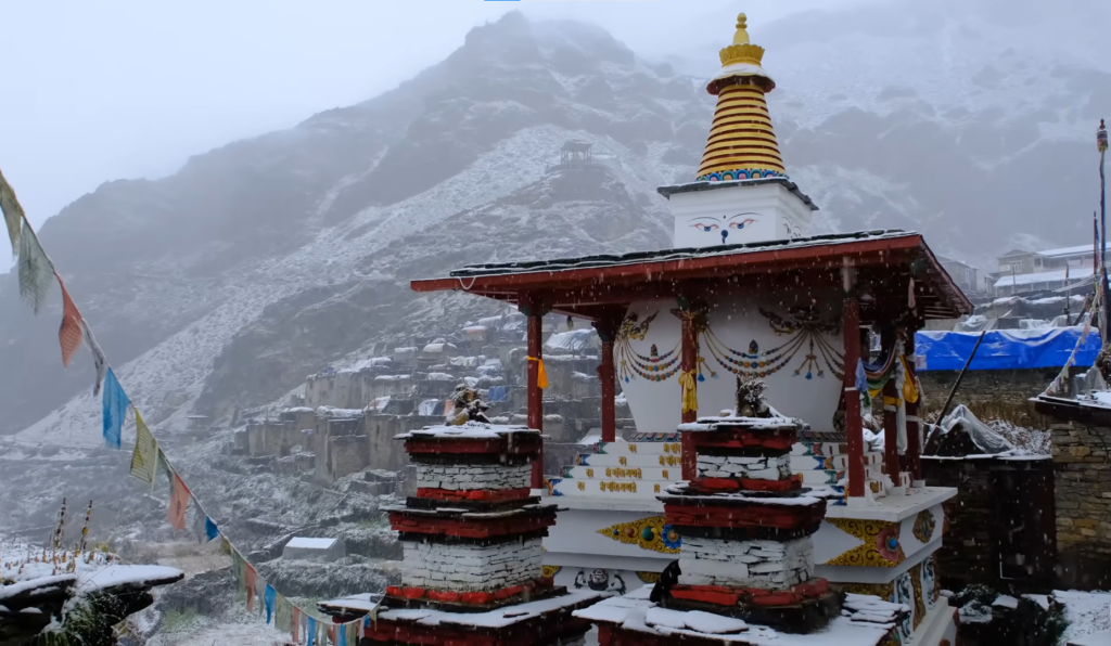
The walk also takes you to one of the holiest places in Nepal for both Hindus and Buddhists, Muktinath. The famous temple complex, eternal flame and 108 water taps welcome pilgrims from all over the country of Nepal and India all year long.
This is the added dimension of a remote mountain life and sacred cultural sites that make this journey feel much richer than a typical point to point trek.
The Nar Phu Valley is a restricted area and a special restricted area permit, along with the Annapurna Conservation Area Permit and TIMS card, is required.
No independent trekking is allowed, all trekkers must trek with a licensed guide through a registered trekking company. Though if you have no group, you can still trek, but with a licensed guide after the latest DOI revised policy.
This increases the logistical challenge but will also help protect the delicate culture and environment of the area and improve the safety of trekkers crossing such far-flung land.
The Nar Phu Valley Trek is best done during the spring (March to May) or autumn (September to November).
These are typically the best times to see the mountains, have good weather, and are the safest times to pass Kang La and Thorong La.
The forest area is rich in rhododendron flowers during the spring and offers long distance views of the Himalayas during autumn through the clear skies in the high valleys and passes.
The trek is equally as scenic and comfortable during both seasons, especially if you are looking for a chance to catch the high passes and remote villages in their best light.
Nar Phu Valley Trek is not just a hike on the mountains, rather it is a true trek across the Himalayas in the least-visited high altitude terrain in Nepal.
Trekking through the isolated Tibetan culture, limited valleys, spectacular canyon walks, two main passes of the Himalayas, and ever-changing scenery makes for one of the most rewarding hikes in the Annapurna region for those seeking something more than your typical trek.
There’s a quietness, a rawness to it, and it’s a great trip to remember from the first time you’re driving out of Kathmandu until you’re back down on the side of the Kali Gandaki, in Jomsom, and Muktinath.
Trip Highlights
- Explore the restricted Nar Phu region, a a rugged, off-the-beaten-path trek, which is situated between Annapurna and Manaslu ranges.
- Follow the Marshyangdi River corridor from Kathmandu to Jagat, then move through Tal, Dharapani and Koto before the trail turns into the hidden valley.
- Walk into the dry upper Nar Phu landscape at Meta, Phu Gaon and Nar, where the villages feel older, quieter and more Tibetan in style.
- Spend a proper acclimatization day at Nar before the Kang La crossing, which helps the body prepare for the next high sleeping and walking altitude.
- Cross Kang La Pass at 5,322 meters and descend to Ngawal with wide views of the Annapurna range, Gangapurna and Tilicho Peak.
- Rejoin the main Annapurna Circuit at Ngawal and Manang, where the trail becomes more familiar and the villages feel slightly more developed.
- Continue from Manang to Yak Kharka and Thorong Phedi, which sets up the final pass day in a sensible and well paced way.
- Cross Thorong La Pass at 5,416 meters and finish the main trekking section at Muktinath, one of the most important pilgrimage sites in the Himalaya.
- Drop into the Kali Gandaki side through Muktinath and Jomsom, then fly to Pokhara for a scenic mountain exit.
- Combine hidden valleys, high passes, Buddhist monasteries and classic Annapurna scenery in one 17 day trek.
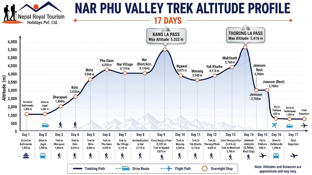
Nar Phu Valley Trek – 17 Days ~ Itinerary
Day 1
Arrival at TIA - Welcome to Nepal
- Altitude: 1350 m
- Accommodation: Standard Three Star Hotel in Thamel
Arrive in Kathmandu and transfer to the hotel. This first day is for rest, airport transfer, trek briefing, and permit preparation so the journey starts smoothly. Our team at Nepal Royal Tourism Holidays also checks the gear and explains the route before the long drive into the Annapurna region begins the next morning.
Day 2
Drive from Kathmandu to Jagat
- Max altitude: 1290 m
- Travel Duration: 8 to 9 hours
- Travel Distance: 210 km
- Meal: Breakfast, Lunch and Dinner
- Accommodation: Teahouse in Jagat
We leave Kathmandu early and follow the Prithvi Highway through Mugling and Dumre before turning north toward the Marshyangdi River valley. The road passes Bhulbhule, Ngadi and the steep canyon sections near Bahundanda before reaching Jagat, where the trek meets the Annapurna side route. Jagat sits on a hill above the river and feels like the first real mountain road stop of the trek.
Day 3
Trek from Jagat to Dharapani
- Max altitude: 1830 m
- Trek Duration: 4 to 5 hours
- Trek Distance: Around 15 km
- Meal: Breakfast, Lunch and Dinner
- Accommodation: Teahouse in Dharapani
The trail leaves Jagat on a suspension bridge and follows the Marshyangdi River through Tal, one of the most scenic village stops in the lower gorge. We continue through Chyamje and climb toward Dharapani, where the valley widens slightly and the old stone village sits under a strong Annapurna backdrop. Dharapani is also the important junction point where the Nar Phu side begins to feel closer.
Day 4
Trek from Dharapani to Koto
- Max altitude: 2610 m
- Trek Duration: 5 to 6 hours
- Trek Distance: Around 14 km
- Meal: Breakfast, Lunch and Dinner
- Accommodation: Teahouse in Koto
From Dharapani, the trail climbs through Bagarchhap, Danaque and Temang, moving gradually into a cooler forest belt with stronger mountain views. Koto is the checkpoint village for the Nar Phu restricted area, so the atmosphere changes here from normal Annapurna trail traffic to a quieter and more controlled mountain entry point. The lodges are small, and the evening feels much calmer than the lower valley stops.
Day 5
Trek from Koto to Meta
- Max altitude: 3650 m
- Trek Duration: 7 to 8 hours
- Trek Distance: Around 12 km
- Meal: Breakfast, Lunch and Dinner
- Accommodation: Teahouse in Meta
Leaving Koto, we turn away from the main circuit and enter the Nar Phu gorge, where the trail climbs through a much drier and more remote landscape. The route passes Ghusang and open ground before reaching Meta, which feels like the first real high valley settlement on the trail. By this point the forest has thinned and the valley feels much more open and exposed.
Day 6
Trek from Meta to Phu Gaon
- Max altitude: 4250 m
- Trek Duration: 6 to 7 hours
- Trek Distance: Around 10 km
- Meal: Breakfast, Lunch and Dinner
- Accommodation: Teahouse in Phu Gaon
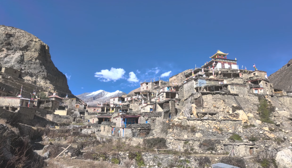
The trail from Meta into Phu follows a narrow gorge and then opens into a dramatic upper valley where the river has cut deep into the rock. We cross mani walls, chortens, and old stone paths before reaching Phu Gaon, a compact Tibetan style village with monastery culture and a strong feeling of isolation. The high altitude is obvious here, and the evening is quiet and cold.
Day 7
Trek from Phu Gaon to Nar
- Max altitude: 4110 m
- Trek Duration: 6 to 7 hours
- Trek Distance: Around 9 km
- Meal: Breakfast, Lunch and Dinner
- Accommodation: Teahouse in Nar
We leave Phu and move back along the valley before crossing toward the Nar side. The route passes open pasture, side ridges and old monastery ground before the stone houses of Nar appear in the afternoon. Nar feels more exposed than Phu, with prayer wheels, tight lanes, and a strong village identity that is still very much alive.
Day 8
Acclimatization and preparation at Nar
- Max altitude: 4110 m
- Trek Duration: 3 to 4 hours on the acclimatization walk
- Trek Distance: Around 3 to 5 km
- Meal: Breakfast, Lunch and Dinner
- Accommodation: Teahouse in Nar
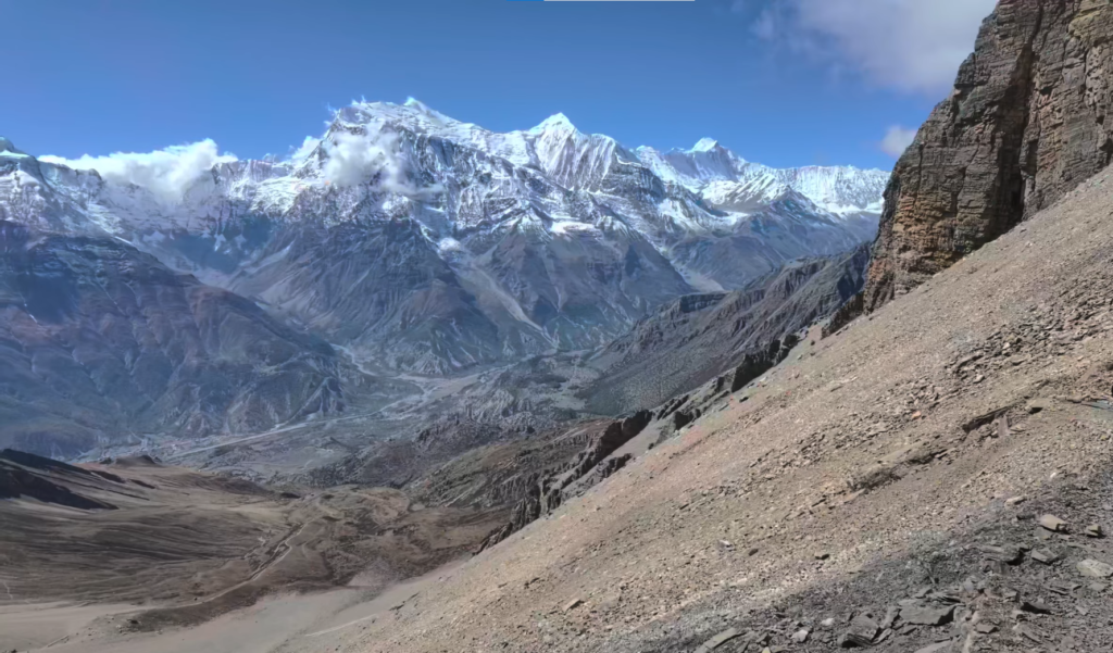
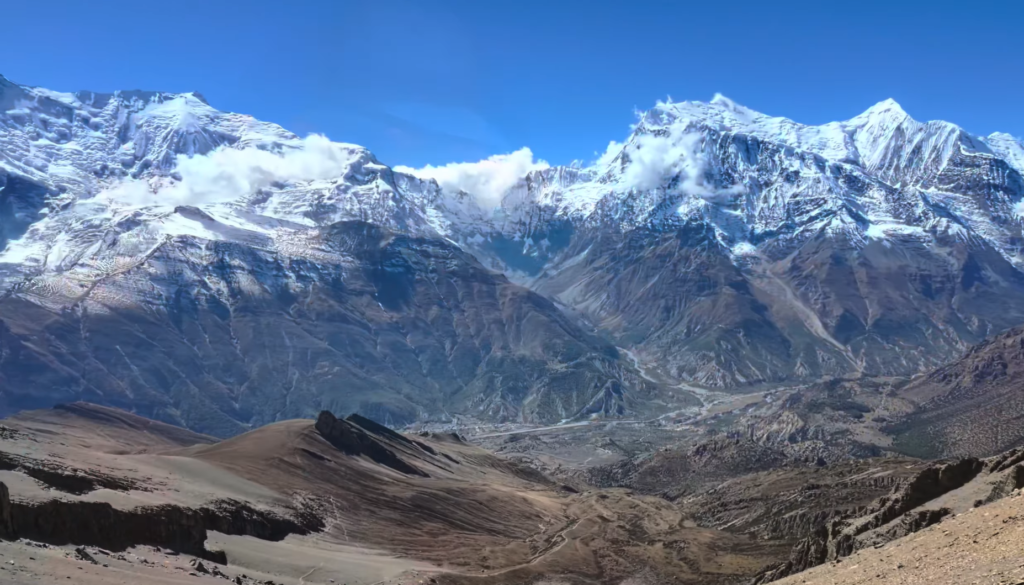
This is the acclimatization day before Kang La. We take a short uphill walk above the village, which helps the body adjust while also opening the view toward the Annapurna side. Nar is also the right place to spend time with the local monastery, prepare gear, and keep the next day light and early. From the ridge above Nar the views south across the Annapurna ranges are extraordinary, with Annapurna II, IV, and the Gangapurna glacier all clearly visible.
Day 9
Trek from Nar over Kang La Pass to Ngawal
- Max altitude: 5322 m
- Trek Duration: 7 to 9 hours
- Trek Distance: 14 to 16 km
- Meal: Breakfast, Lunch and Dinner
- Accommodation: Teahouse in Ngawal
This is the toughest and most important day in the first half of the trek. We climb early from Nar through yak pasture and scree before reaching Kang La Pass, where the views open wide over the Annapurna range and the surrounding high ridges. The descent to Ngawal is long but rewarding, and the village sits on a ridge with a clear upper Manang feel. The panorama from the top is one of the finest on any trekking route in Nepal, Annapurna I, Gangapurna, Manaslu, and the Fishtail pyramid of Machapuchare all visible simultaneously.
Day 10
Trek from Ngawal to Manang
- Max altitude: 3540 m
- Trek Duration: 3 to 4 hours
- Trek Distance: Around 12 km
- Meal: Breakfast, Lunch and Dinner
- Accommodation: Teahouse in Manang
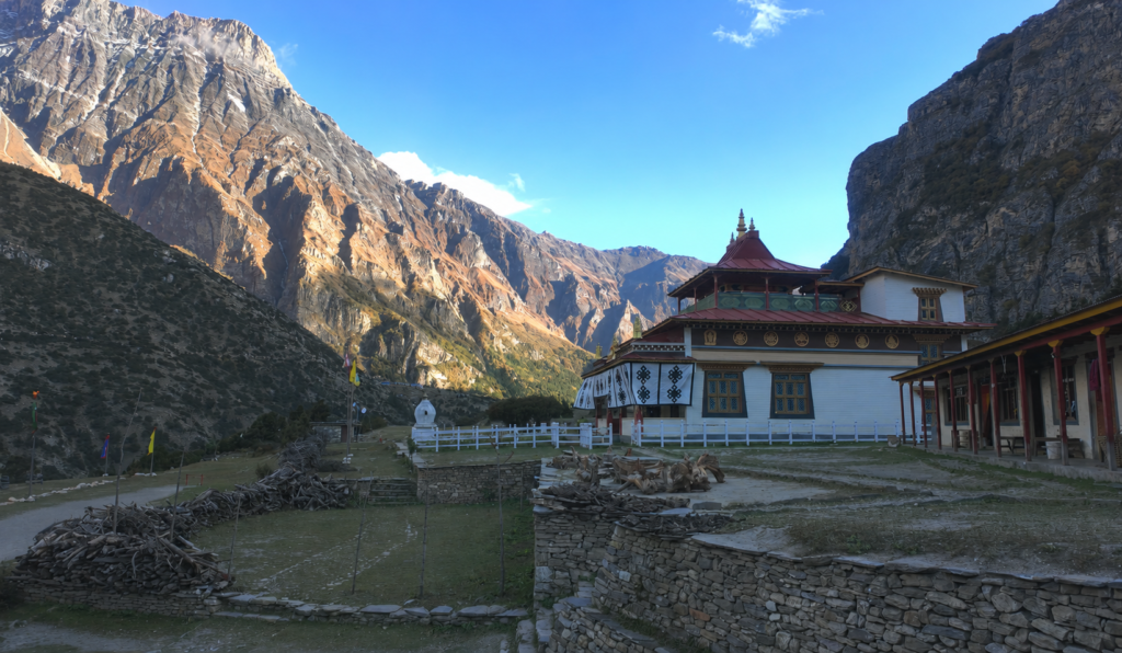
From Ngawal, the trail drops through open country to Braga and then into Manang, which is the main settlement hub of the upper Marshyangdi Valley. Manang gives us better lodge options, bakeries, shops and a strong place to recover before the next climb. The afternoon is useful for a short walk or a visit to the local monastery and viewpoint above the valley.
Day 11
Trek from Manang to Yak Kharka
- Max altitude: 4110 m
- Trek Duration: 3 to 4 hours
- Trek Distance: Around 9 km
- Meal: Breakfast, Lunch and Dinner
- Accommodation: Teahouse in Yak Kharka
We leave Manang and climb past the fields and upper slopes toward Yak Kharka, the high pasture stop before Thorong Phedi. The trail passes through the ecological zone and gives clear views back toward the valley, while the air begins to feel thinner and colder. Yak Kharka is small, simple and well placed for the next section. A short thirty-minute walk above the lodges to gain a bit more altitude before returning is a standard acclimatization technique that we recommend.
Day 12
Trek from Yak Kharka to Thorong Phedi
- Max altitude: 4600 m
- Trek Duration: 4 to 5 hours
- Trek Distance: Around 10 km
- Meal: Breakfast, Lunch and Dinner
- Accommodation: Teahouse in Thorong Phedi
The trail climbs gradually into the Thorong side valley, where the route becomes more serious and the pass looms ahead. Thorong Phedi is the base stop used by most trekkers before Thorong La, and it is where we rest early because the next day starts before sunrise. The lodges are basic, but the position is ideal.
Day 13
Trek from Thorong Phedi over Thorong La Pass to Muktinath
- Max altitude: 5416 m
- Trek Duration: 7 to 9 hours
- Trek Distance: Around 19 km
- Meal: Breakfast, Lunch and Dinner
- Accommodation: Teahouse in Muktinath
Thorong La Pass at 5,416m is the highest point of the Annapurna Circuit, the highest point of this entire 17-day journey and one of the most memorable days in Nepal. We start early, climb to Thorong La in the dark or first light, and then look out over Annapurna, Dhaulagiri and the wider Mustang side before descending to Muktinath. The temple area is sacred to both Hindu and Buddhist pilgrims, and the change from high pass to holy valley is one of the strongest parts of the trek.
Day 14
Trek from Muktinath to Jomsom
- Max altitude: 2760 m
- Trek Duration: 4 to 5 hours
- Trek Distance: Around 18 to 20 km
- Meal: Breakfast, Lunch and Dinner
- Accommodation: Teahouse in Jomsom
We descend through the upper Mustang side, passing Kagbeni and then following the Kali Gandaki corridor toward Jomsom. The scenery becomes drier, wider and windier, and the valley opens fully between Dhaulagiri and Nilgiri. Jomsom is a practical overnight stop before the flight out the next morning.
Day 15
Fly from Jomsom to Pokhara
- Max altitude: 2760 m
- Flight Duration: Around 30 minutes
- Trek Distance:
- Meal: Breakfast and Lunch
- Accommodation: Standard Three Star Hotel in Pokhara
The short flight from Jomsom to Pokhara gives one last clear look at the Annapurna and Dhaulagiri side before we drop back into the lakeside city. Pokhara feels very different after the high valleys, so the afternoon is usually free for rest near Phewa Lake or a quiet walk through Lakeside.
Day 16
Drive from Pokhara to Kathmandu
- Max altitude: 1350 m
- Travel Duration: 6 to 8 hours
- Travel Distance: Around 200 km
- Meal: Breakfast and Lunch
- Accommodation: Three Star Hotel in Thamel
We leave Pokhara after breakfast and drive back to Kathmandu along the Prithvi Highway. The route follows the river corridors and roadside towns of central Nepal before reaching the capital by evening. This is a long transfer day, but it closes the trek in a comfortable way. The road follows the Seti Gandaki and then the Trishuli River, passing through the busy junction town of Mugling where we stop for lunch.
Day 17
Final Departure
- Meal: Breakfast
After breakfast we transfer you to the airport for your onward flight. This is the final day of the Nar Phu Valley Trek and the end of the full circuit through the hidden valleys and the Annapurna high route. We, at Nepal Royal Tourism Holidays are extremely grateful for the opportunity we got to assist you during the trek.
Nar Phu Valley Trek – 17 Days Fixed Departures Dates
Trip Cost Includes/Excludes
Cost Includes
- Airport pick up and drop off in Kathmandu
- Three Star Standard hotel accommodation in Kathmandu and Pokhara
- Private/ Sharing transport from Kathmandu to Jagat and Pokhara to Kathmandu return according to your group size
- Domestic flight from Jomsom to Pokhara
- Teahouse accommodation during the trek on twin sharing basis
- Three meals during the trekking section
- Licensed English speaking trekking guide and a porter (2 pax 1 Porter)
- Required permits for Nar Phu and the Annapurna section
- Government taxes
- Trekking completion support and trip coordination
- Nar Phu Trek completion certificate and Nepal Royal Tourriim Holidays t-shirt
Cost Excludes
- International airfare to and from Nepal
- Nepal entry visa fee
- Travel insurance with high altitude evacuation cover
- Tips for guide, porter and driver
- Drinks, snacks, hot shower, charging, Wi Fi and other personal expenses
- Extra nights in Kathmandu or Pokhara caused by delays or personal plans
- Personal trekking gear and equipment
- All other costs that is not included in the "Includes" section
Trip Photo/Video Gallery


Route Map for Nar Phu Valley Trek – 17 Days
Frequently Asked Questions
The trek requires a restricted area permit for Nar Phu, along with the Annapurna Conservation Area Permit and a TIMS card. Current government rules also require trekkers in restricted areas to travel through an authorized agency, with a licensed guide.
This is a challenging trek because it combines remote trail sections, long walking days, and two high passes above 5000 meters. The route is not technical climbing, but fitness, patience and altitude awareness matter a lot.
The best seasons are spring and autumn, when weather and visibility are usually more stable. Those months give the best chance of clear views across Kang La, Manang and Thorong La.
Yes. The restricted area rules require a licensed guide, and solo independent trekking is not allowed in this region. However, a single person can do this trek with a certified guide.
Accommodation is basic tea house style in the Nar Phu section, with better lodge comfort once we return to the main Annapurna route. Nar and Phu are simple, quiet, and well suited to trekkers who are comfortable with rustic mountain lodging.
Kang La is about 5322 meters. It is the key crossing that takes the trail from Nar into the Ngawal side of Manang.
Thorong La is 5,416 meters and is the highest point on this 17 day route. It is the final big pass before Muktinath.
It is better suited to trekkers who already have some high altitude experience. A very fit beginner can complete it with good preparation, but this is not the easiest first trek in Nepal.
The route gives strong views of Annapurna II, Gangapurna, Tilicho Peak, Annapurna I, Dhaulagiri and the wider Mustang skyline depending on the section of the trail.
Yes. That is exactly what this 17 day version does by joining the circuit at Ngawal and continuing through Manang, Yak Kharka, Thorong Phedi, Thorong La, Muktinath, Jomsom, Pokhara and Kathmandu.
Yes, altitude sickness can be a concern especially on a trek above 5000 meters. We advice you to consult your guide if you feel any discomfort, as even minor issues should not be compromised. To reduce these issues, our treks is planned in such a way trekkers gain elevation slowly and acclimatize accordingly.
Leave a Review
Nar Phu Valley Trek – 17 Days
5 Reviews to Nar Phu Valley Trek – 17 Days
You may also like

3 Nights 4 Days Chitwan Jungle Safari Tour | Wildlife Adventure in Nepal
-
Trip
4 Days
-
Grade
easy
-
Altitude
415m
Daniel Roberts
at 7:00 pm
Incredible Nar Phu Valley Experience
Magnificent scenery, serene paths, and the Tibetan culture which is one of a kind, all contributed to making this trek a memorable one. Thank you Nepal Royal Tourism for the professional and friendly services provided.
Michael Turner
at 11:05 pm
Amazing Hidden Valley Adventure in Nar Phu
I had an amazing time on the Nar Phu Trek with Nepal Royal Tourism. Beautiful mountain views, local culture at its best, guide support that was extremely helpful. I would definitely recommend it to others.
Emma Collins
at 8:30 pm
A Perfect Himalayan Adventure
This was probably one of the best trekking experiences in my life. The Nar Phu trail is stunning and the crowd is very less. Nepal Royal Tourism provided excellent service all through the journey.
Sophie Bennett
at 10:30 pm
Best Off-the-Beaten Trek in Nepal
Nar Phu Valley is indeed a hidden treasure. Nepal Royal Tourism took care of all the arrangements, and our guide made the trekking safe, enjoyable, and memorable.
Lucas Anderson
at 3:04 pm
Highly Recommended Nar Phu Trek
Great arrangements, expert guide, and amazing landscapes. Nepal Royal Tourism helped us make the Nar Phu Trek a smooth, safe, and unforgettable experience.